RECAP:
It was a pretty crummy weekend, wouldn't you agree? Overcast with on and off showers Friday to Sunday. An upper level low is slowly moving east as it spins unsettled weather over our area. Oddly enough, this upper level low plays a key role in Hurricane Matthew's projected track. More to come!
10/03 - 10/08 Forecast:
The chance for light showers continues into Monday. I think they will be pretty isolated as the ULL exits off the coast and High Pressure tries to take over. This will also be the warmest day of the week. High temperatures should reach the mid-70's. By Tuesday, the threat for showers exists primarily in the morning. The tail end of the ULL will still be attached to the coast, so overcast skies will remain, but slowly we're drying out. High temperatures will be near normal around 68 degrees. High Pressure fully takes over Wednesday through Friday. Mainly sunny skies with temps ranging from the upper 60's to low 70's. Winds should be calm. Saturday is when the forecast could get a little hairy depending on what happens with Hurricane Matthew. A frontal boundary along a trough is approaching from the west. If this trough feels the tropical energy Matthew is exerting, then rainfall will be enhanced along the front. However, the timing of this trough is unclear. Right now, I am thinking Saturday will be mainly dry and later in the day clouds could increase with showers moving in very late. High temps in the lower 70's.
Long Range:
In last week's Mo Mo I made mention of Hurricane Matthew in the long range section. Believe it or not, we're as unclear with Matthew this morning as we were this time last week. His steering pattern is very complex and guidance is unable to latch onto agreement of his timing.
GFS:
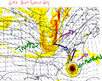
The American model has Matthew off the coast of South Carolina Saturday morning. This model has waffled between a path up the coast or out to sea. As Matthew comes up the coast from Florida, an oncoming trough from the west is also working itself toward the east coast. If the trough and Matthew follow the blue arrow paths, then this trough will work to "reel" Matthew into the coast for landfall somewhere between VA and New England. If the trough and Matthew follow the purple arrow paths, then Matthew will remain offshore. It's possible one can follow a blue arrow path while the other follows purple. In other words, it's possible Matthew can follow the blue arrow while the trough retreats to the north (purple arrow). That means Matthew would come straight up the coast being steered by the WAR (West Atlantic Ridge).
EURO:
The EURO also has Matthew off the coast of South Carolina Saturday morning (slightly south of GFS), but this model stalls him there for a day or two. Notice how the trough is completely different on the EURO. It's already retreating into Canada, while the GFS has it fairly steep near the TN valley. Because the EURO stalls Matthew and the trough is in Canada, he just stalls off the southeastern coast because he's trapped between a ridge over Texas and the WAR.
Fast forward a couple of days on the EURO, and Matthew is now north making his move up but pretty off the coast. In the mid-section of the country, there is a weak trough, or piece of upper energy, working its way east. If this energy reaches the coast with Matthew in reach, then it has a chance to reel him into landfall. IF that piece of energy catches Matthew, he's likely to take the blue track closer to the coast instead of the one pointing out to sea. This also means that impacts for our area would not be until October 10th - 12th (likely the 11th-12th). Essentially, Matthew is still in "fantasy" land on the EURO and taking solutions too seriously now are not warranted. We're better off waiting a couple of days to see if models can begin to agree on timing of the storm.
At this juncture, I do not feel comfortable trusting the GFS American model. Each run it has progressed slower and slower leading me to believe the EURO may have the right idea with timing of the storm. If this is the case, then the trough working its way east and the ULL do not play much of a factor in determining Matthew's forecast since they should be out of the picture by the week of the 9th. If somehow the GFS is right with bringing Matthew up the coast late this week into the weekend, then the ULL and trough become critical in where they're positioned.
At this time, I want to see another day or two of model runs to see if we can get the timing down. Once we have that, we'll be able to draw better conclusions on Matthew and where he may possibly go. One thing is for certain: he will track between Haiti and Jamaica, hit or clip eastern Cuba, then bring a whole lot of trouble to the Bahamas. He may enter the Bahamas as a major Hurricane and sit over those islands for 1-2 days. How close to the coast of Florida he gets will also be interesting to see. The further west he gets, the higher the odds he could come up the coast.
Interesting times ahead! Stay tuned to the forum.
Have a great week.
Best,
Francesco Paparatto
Join the forum at www.njstrongweatherforum.com


No comments:
Post a Comment