What gives!?
One thing I do find interesting is subsurface temps. in the Pacific since mid to late May have been rising.
The ONI value for June, July, and August is not in yet, but I'm fairly certain it will show a positive (warming) trend in the 3.4-Nino region since real-time data continues to show gradual warmth over that area in the last month. For May, June, and July...the ONI was at -0.2 which is indicative of ENSO-neutral. In fact, "La Nada" has been in effect dating back to March of 2012. Therefore, the ENSO has not had any affect on our weather pattern for the last year and a half!
Check out the two 500mb anomaly images of the Pacific Ocean from the 12z GFS below. The first one is valid for September 6th and the second one is valid for September 11th.


Both of these images show positive height anomalies continuing in the Pacific for at least the 1st half of September. There is even constant ridging being shown in the Pacific Northwest of the U.S. (upper right corner of those maps). What this is telling me is the Pacific is undergoing a transition of breaking out of the year and a half long La Nada and trying to emerge into an El Nino state. I can not say with guarantee we are heading toward an El Nino until official reports and observations from the Nino regions prove otherwise. But latest indices are enticing, to say the least. One thing for sure is La Nada will persist through the upcoming fall season.
How about the Atlantic Ocean?

The NAO has been positive for much of the summer. Ridging has been concentrated in the central Atlantic, while the northeastern Atlantic (near Greenland) has been under the influence of trough's. Between the ridging in the Pac. NW and the central Atlantic, the eastern CONUS has enjoyed an average Meteorological Summer with episodes of troughs getting into the region.
This has allowed the SAL (Saharan Air Layer) to remain intact over the Atlantic for much of the season. This GIF taken from WeatherBell will show you what I mean...

The colors represent the dust coming out of western Africa. A new wave of SAL is set to come off of Africa by the weekend.
Between the combination of westerly winds in the eastern U.S. caused by the constant ridging in the west, the SAL in the Atlantic, and the lack of blocking in Greenland...the hurricane season has not gone as expected thus far in 2013 (even with an MJO favored for tropical development). Additionally, the recent trend of warming in the Pacific has caused the upper level wind flow in the Atlantic to remain unfavorable.
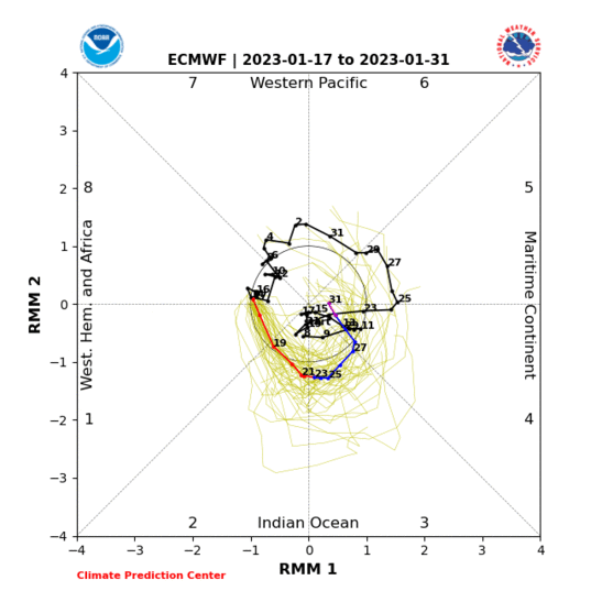
Speaking of MJO, the EURO wants to take it into the COD (circle of death) by next week:

The only silver lining I see for those who are looking for tropical development is some long range models are trying to push a ridge into the eastern U.S. which would force the ridging over the central Atlantic to propagate east-northeastward. Whether this comes to fruition or not remains to be seen. Also, it only takes one storm to really make a hurricane season one to remember. There is still the 2nd half of September (I'm forecasting 1st half of September to remain quiet) and all of October. We'll see what happens.
Take care,
-Frank
Notes:
1. Register to the NJ Strong Wx Forum. Now up to 183 registered members with lots of great minds to share valuable information
2. 2013-2014 Winter Outlook to be released Thanksgiving Day.

No comments:
Post a Comment