Sunday, September 25, 2016

September 26, 2016 Mo Mo: Rain Relief on the Way

NOTES:
-Click on images in blog to enlarge for better view
-Turn volume up to listen to blog song

BLOG SONG: "Be as You Are" by Mike Posner

RECAP:

Man, what a fabulous weather weekend. Saturday started off cloudy but the sun came out by the afternoon. Temperatures felt fall-like in the lower 70s and 60s with not much humidity. The area is in desperate need of rain. All summer long its been relatively dry and lawns across the tri-state look as dry as the Sahara right now. Luckily, rain relief is on the way this week. 

09/26 - 09/30 FORECAST:

A pleasant start to the week. High pressure in control on Monday will keep us under sunshine with high temps in the low to mid 70's. Winds will turn from the north to the south as a front approaches the area by the evening. 

Early Tuesday morning, after Midnight, rain will move into the area and last until mid to late morning. The further northwest you live, the faster you will dry out on Tuesday. Rain could be over for northwest sections as early as 8am on Tuesday. (Figure 1)


Figure 1 - rain overspreading the area along a frontal boundary 

Wednesday will be much like Monday. Sunshine to start the day with high temps in the low to mid 70's with increasing clouds by the evening. By late evening, rain will move into southern sections of NJ and gradually spread north overnight. 

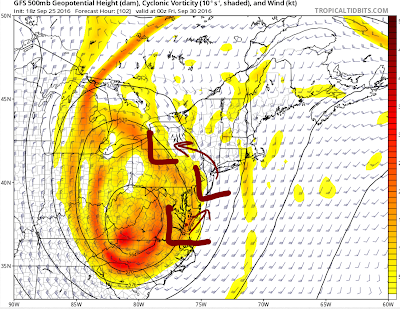
Thursday - Friday will feature a coastal storm, a Nor'easter in fact, that is expected to bring moderate rainfall to the area. The upper level pattern is conducive for a coastal storm to impact the area (Figure 2 & 3)


Figure 2 - An Upper Level Low over the Ohio Valley is caught under a couple of ridges to its north, which slows the jet stream down and allows a surface low to develop along the coast. 


Figure 3 - a zoomed in look of the 500 mb ULL. The "L'" represents the surface low and the track it's expected to take. 


This will not be a potent Nor'easter. The surface low pressure is expected to stay above 1000 mb and winds will not exceed 20 mph. The large Upper Level Low coming from the west is not working with impressive jet dynamics that would be able to enhance this system. That is not to mean there will not be a good amount of rain. Models are showing moderate to heavy rainfall overspreading the area Thursday afternoon and lasting into the evening (Figure 4). Rain will continue into Friday though it is expected to be more on and off by then. There could be a break from the rain Friday morning then another round of light showers later in the afternoon. High temperatures may not get out of the 60's THU-FRI due to the rain. Going to be pretty raw outside...ew. 


Figure 4 - Heavy rain forming over the Tri-State Thursday afternoon

All together, the rain we see this week should exceed 2-3 inches for most locations (Figure 5). I do not know about you, but I am quite glad we're getting some. Fall foliage is still going to look pretty crappy this year since its been a dry summer. However, there are places in the elevated sections of NJ and NY that look nice regardless of the wet season.


Figure 5 - Total rainfall for the week with most of it falling Thursday-Friday from the Nor'easter. Some spots could see isolated 4" of rain. Localized flooding possible. 

Some leftover clouds on Saturday but for the most part it should be dry and sunny with temps back into the 70's. 

LONG RANGE:

While the upcoming week will remain seasonable, guidance is in fair agreement of warming temperatures returning to the area. Possibly hitting the 80's once again. The GFS and EURO Ensembles suggest a trough will enter the Pacific Northwest and a ridge builds over the Northeast (Figures 6 & 7). 


Figures 6 (GEFS) & 7 (EPS) show a ridge, pointing to above normal temperatures, building over the Northeast between October 2nd - October 7th. 

The above normal temps, possibly in the low 80's (in October!), is not the ambiguous part to the forecast that week. It will be the possibility of a tropical entity affecting our area. Models are showing a large Hurricane, likely to be named Matthew, over the Atlantic at that time. However, some models also show this system heading into the Gulf of Mexico. There is a large spread of guidance on where he will track. Here are the likely storm tracks:

A) Into the Gulf of Mexico with landfall between TX and FL

B) A direct hit somewhere along the east coast, most likely between FL and NC then up the coast 

C) A re-curve out to sea 


As details become more certain and models come into better agreement, I will release another blog outlining the weather impacts, whether direct or indirect, this system will have for our area. Look at the size the GFS blows this storm up to (Figure 8). Pretty scary. Hopefully it stays far far away. 


Figure 8 - Soon to be Hurricane Matthew on the 18z GFS. A category 4 Hurricane for sure west of Bermuda and east of the U.S. East Coast. Too close for comfort indeed...


I hope every has a fantastic week! Thanks for reading.

Best,

Francesco Paparatto


Be sure to stay tuned to the forum for latest development and breaking weather news.


Friday, September 2, 2016

Hermine Not Backing Down

Remember 99L? Oh yea, that was Hermine. Many have been tracking Hermine for nearly 2 weeks. Models struggled to agree on a track and how strong she will get. Tonight's 00z and tomorrow's 12z model runs hope to give us answers to some glaring unknowns just 36 hours before rain starts to fall.

Hermine is currently over North Carolina bringing flooding rains. She is moving quickly to the north-northeast. Early in the frame you can clearly make out the core and where the "eye" was. In the last 2 frames it's clear the eye has become exposed and Hermine has weakened from a Hurricane to a Tropical Storm as she spins over land. She is expected to move back over water and regain strength as an extratropical storm. 


TPC's track nicely shows how Hermine's resurgence over the Atlantic. She is likely to become a Hurricane again late Sunday or early Monday. Tropical Storm warnings and watches are in effect for the Tri-State area. 


As Hermine tracks north, she is going to run into High Pressure which acts as a block. This block will force Hermine to retrograde back west toward the coast instead of meandering out to sea. This is a big blow for residents on the NJ shore and south shore of LI because a full moon is in the forecast this weekend. The strength of a category 1 Hurricane moving due west + overlapping tide cycles due to the slow movement will result in disastrous and horrific storm surge. These areas could be looking at a surge of 7 to 8 feet if latest model guidance comes to fruition. 


Here is a look at 500mb height anomalies from the 12z EPS. This gives you a better look of the block to the north. The ridge prevents Hermine from escaping out to sea. As she departs North Carolina, she is expected to track NNE and get fairly far east before turning back west. This is the main reason why the storm surge forecast looks nightmarish for folks along the coast. 


The teal line is the track I expect Hermine to take. It is not much different from the one I showed yesterday. I think the retrograde will occur east of the Delmarva before heading NNE, where she is likely to stall for 2 full days. How far west in her retrograde does she go is the main question left to be answered. 


Check out these 925mb winds from the GFS and their time stamps. Sustained Tropical force winds over much of the area is possible for 2-3 days. The yellow shading translates to 35-50mph winds at the surface, while the red could mean gusts at Hurricane force for the immediate coast and 60-70mph for those just inland. The issue is these winds will remain with us for longer than 2 days since Hermine is expected to stall off the coast. The combination of high winds and rain could lead to prolonged power outages, especially since for safety reasons many powerline crews do not begin repairs until the winds die down. 


Figuring out how much rain falls is the trickiest part of the forecast since we're uncertain with Hermine's exact track still. Look how close the purple, blue, and grey shadings are to the coast. A shift of just 50 miles west puts much of NJ in flooding rain. The NJ shore and east end of Long Island is a good bet to see at least 3 to 6 inches of rain. Add the 5-7 foot storm surge and near Hurricane force winds, the NJ shores are in line for a very dangerous storm and they should start making preparations NOW.


One thing that caught my attention is dry air tries to get entrenched into this storm by early Monday. That could hinder rainfall totals a bit, especially for those away from the coast. Something to watch...


Take note that I am forecasting winds for the brunt of the storm. There will be times on Tuesday and Wednesday where these winds will verify too (see graphic with time stamps). Overall, I expected Tropical Storm force winds for those in red over a 2-day period with Hurricane Force (74+ mph) very likely for a period of time Sunday night into Monday early afternoon. 850mb winds are shown to be over 75mph in some locations. Those in blue will see Tropical Storm force winds too, but probably not over 2 days worth. Again, this is a tricky forecast because if Hermine tracks closer to the coast then the Hurricane Force winds could extend further inland. It will not take much for that red to overspread much of the area. Regardless, TS force is still bad and could cause many issues. 

I have low confidence with my rain forecast. I expect to have an update out tomorrow afternoon with updated maps. I am confident the NJ shore will see at least 3" of rain, but it could also go as high as 10" depending on the track. 

Another historic storm for the east coast. What a time to be alive if you're a weather junky like me. The dynamics at play and unprecedented track make Hermine one of the most unique tropical systems I've ever tracked. I noticed some of the news outlets may be underplaying Hermine a bit. While I do not think this will be Sandy-level, she will kind of be Sandy-like with the due west movement toward the coast and that in itself could be disastrous for the shores. 

More to come tomorrow. I will have more in the way of timing and impacts. 

Have a good night.

-Francesco Paparatto