Sunday, January 19, 2014

Examining The January 21st Snowstorm

Click on images to get larger view

A disruptive snowstorm is eyeing the I-95 corridor beginning Tuesday morning and continuing into early Wednesday morning of this week. A potent piece of energy will be ejecting out of south-central Canada Monday night with the Polar Vortex situated to our north. Along with a few other variables, including the very cold temperatures, this is setting the scene for a moderate storm to impact the area.

Lets first take a look at the players on the field and where they are positioned on each model (GFS and EURO):

00z GFS:


At hour 42 per the 00z GFS, there is a +PNA (western ridge) with positive heights extending into Alaska. Toward southeastern Canada, there is a weak Polar Vortex and a piece of its energy will be breaking off and digging into the trough in the eastern U.S. It is able to dig mainly due to the massive ridge in the west. Lastly, just like the January 3rd storm from earlier this month, there is last minute blocking, or -NAO, showing up on the models that is allowing the PV and the ULL over Newfoundland to to stay put and help slow the storm down a bit once it develops. This also helps the trough go negative since the progressive nature of the pattern is cut-off. At this point, the trough in the eastern U.S. is neutral and the energy is really digging. 


By hour 51 of the 00z GFS, which is late Tuesday night or early Wednesday morning, the GFS has brought the trough negative and this is where the storm reaches its height with moderate snow falling and extremely cold temperatures in place. The arctic-like temperatures would help raise the ratios from 10:1 to at least to 15:1 and 20:1 in some cases. You can see from the above map that the blocking the GFS outputs is impressive which is why at the 00z run it came out with an impressive solution of widespread 3 to 6+ inch snowfall amounts region-wide. 

00z EURO:

The EURO model caved west from its 12z run, but is still not as impressive as the GFS and a couple other short-range models in the snowfall department. 


At hour 54 of the 00z EURO, you can see the trough does go negative and there is region-wide light snowfall accumulations (especially in SNJ, coastal NJ, and LI), but the storm does not have a chance to amplify and slow down. The biggest reason for this is because of the "kicker" like piece in south-central Canada circled in black on the map above. Due to the weak state of the PV, there are a lot of upper level s/w energies retrograding and spinning to our north and this one is particular is trying to kick our coastal storm out to sea. The GFS model has this piece further north and west hence why it shows a more impactful snowstorm for the area. 


Taking a closer look at the h5 vort maps (GFS top, EURO bottom), at hour 48, you can see the EURO has the trough still in a mainly positive state while the GFS is already at neutral. You can also see that feature northeast of Maine on the 00z GFS that looks like an upper level low that could be helping to bring the trough toward a negative state sooner, whereas the EURO does not have such thing. 

Amazingly, these are pretty big differences with two very well known global models in the upper levels. Whichever one turns out to be correct will ultimately determine how this storm will evolve. 

Temperatures:

Just so you have an idea, this is what temps are expected to look like as snow is falling Tuesday night


Mainly low 20's to mid teens and colder as you head north and west (but those areas will also see less snowfall). In fact, temps are looking to remain very cold through the rest of the week. So whatever snow falls will stick around for quite awhile. This will raise snow ratios to at least 15:1 and potentially higher. 


Winds:


Winds are expected to be particularly bad for coastal NJ and Long Island, especially the east end. Blizzard-like conditions are possible for central and eastern LI since the cold temperatures will cause this snow to be powdery, meaning the winds will easily kick it up and reduce visibility. There exists the chance the NWS issues blizzard watches for this area Tuesday night into Wednesday morning. 

Ultimately, we have to see more model guidance to see which direction they decide to go in. The upper levels between the GFS / EURO are drastically different but both models still bring a light snowfall event to the area. Regardless, we should be looking at some accumulating snowfall beginning late Tuesday morning and lasting into Tuesday night. 

A snow map will be posted this morning at 11 am on the forum. I will also detail the timing of the storm at that time. 

Happy MLK Day! 

-Francesco Paparatto 


*Please register to the www.njstrongweatherforum.com for continuous updates on the storm* 


Monday, January 13, 2014

Update On 1/15 - 1/18 Storm Threats, Big Time Cold Temperatures To Return

Last week I issued a blog looking at storm potentials this week that could bring disruptive snow to the area. Revisiting those threats again this morning, it looks like we will be in the clear of a big storm to effect the region. However, there could still be a period of light snowfall that brings minor accumulations to parts of the Tri-State. 


The two dates of interest I mentioned in my last blog was 1/15 and 1/18 since both dates will feature a trough dropping into the eastern CONUS. Above is the 500 mb vort map for the 1/15 threat. There is still a good amount of energy ejecting out of Canada and into the trough that should still spark some light snowfall to develop from the Apps and points east to the coast. But due to the lack of spacing between both pieces of energy, it does not allow the initial trough to amplify along the coast and organize a pinched off surface low.


The next threat is on 1/18. Since the "kicker" feature behind this trough is not as pronounced (as you can see from the above 500 mb map), there could be a more widespread area of light snowfall on Friday. The s/w energy with this trough is not as impressive as the 1/15 event, but the trough takes on a bit more of a negative tilt. So, this threat still bares watching and there could be an area of 1-3 / 2-4 inch type of snowfall somewhere in the northeast region (possibly more in New England). It's dependent on exactly where the energy transfer occurs associated with the clipper system in the Great Lakes during this time period. 

Therefore, I would pay more attention to potential snowfall for Friday and pretty much write off Wednesday from anything of importance happening other then a nuisance snow or rain shower. 


Looking ahead, there is still a strong signal from the current observations of SST's in the northern Pacific of another -EPO regime developing by the end of this month. I think we are going to look at a few possibilities:

1. A -EPO/-PNA pattern develops again similar to what we saw in December / early January. 

2. A -EPO/+PNA Pacific set-up develops. 

3. A +EPO/+PNA Pacific set-up develops. 

Given the look of current observations and some long term guidance, I am liking a combination of options number 2 & 3 to come together. The -EPO will enter a relaxation period, but I think it reforms in conjunction with a western U.S. ridge. If this combination of incredible western northern hemisphere blocking comes to fruition, it will call for arctic air and a persistent trough to reign over the eastern U.S. once again. 


The MJO forecasts from the GEFS (top) and EURO (bottom) are showing signs of life with members taking the MJO out of the circle of death and into phases 6 / 7. The MJO phase 6 does not shock me since early next week we will experience a temporary 1 or 2-day warm-up as the western ridge collapses eastward. But once we get by early next week, that is when our weather pattern becomes interesting and the colder than normal weather settles back in. 


Above are the proposed GFS 2-M Temp Anomalies after the temporary warmup early next week. As you can see, even if this is slightly overdone, it is still an impressive cold air mass coming down due to the western blocking developing like I talked about earlier. 

The question then becomes, will there be a storm to accompany the cold that could turn things white? 

That is something that remains to be seen, and it would be unfortunate to see cold / dry conditions develop the end of this month. Most people like to see snow come with the cold. There's no point in posting long range surface maps, but some of them do show storm threats down the road. The problem is our NAO. Can we get a sustained -NAO to get some blocking to work with which would (4 "w's" in a row, wow) really turn this into a Godzilla-type of pattern? There are signs of a potential sudden stratospheric warming (SSW) event taking place and there is usually a 2-4 week lag time before it reflects on our pattern here in the eastern CONUS. If that comes to light, then a -NAO pattern could be in store for us once we get into February. However, I do not expect a sustained -NAO to come in January, other then transient episodes that could be our window of opportunity to capitalize on come the end of this month. 

We will see what happens. There could be a lot of fun in store for us by week 4 into February! 

-Francesco Paparatto 


*Please register to the www.njstrongweatherforum.com forum to take part in daily discussions about the weather and pattern!*


Friday, January 10, 2014

Winter Storm Threats To Return After Short-Lived Warmth

Once we get through this warm-up period this weekend and early next week, our attention will turn to a pair of upper level trough's that will drop into the eastern U.S. beginning around the 15th of January. Just like our most recent winter storm after the New Year, we have to watch the energy associated within these trough's to see if they spawn a surface low pressure system that could potentially bring widespread snowfall to the area. There are a few things we should monitor these next few days:

1. How strong will the short wave energy be?
2. How much energy gets drawn into the backside of the trough?
3. How does the trough orient itself?
4. Will there be a phase?
5. Will the STJ play a role?

There are many other questions that could be asked but there is simply no way of answering these questions this early in the game. The best we can do at this point is analyze the upper level maps from the models and see if they make sense relative to the pattern. With the last storm, the surface low ended up being further west than where the models intended it to be, and that was due to the poor handling of the trough and the energy associated with it.


There are two threats I want to broadly discuss. The dates for these potential storm threats are between January 15th - 19th. As you can see from the EURO 500 mb maps above (top image is threat #1 around January 15th, bottom image is threat #2 around January 19th), there will be a pair of trough's that drop into the eastern U.S. late next week. There is some weak / transient blocking (-NAO) showing up with ridging in the western U.S. The cold air coming down with these trough's is not as impressive as the cold air we saw with the January 3rd snowstorm, but it's definitely cold enough to support snow. 


The next 4 images are the vorticity maps (EURO top / GFS bottom) that are associated with both storm threats I highlighted above. As you can see, there is an impressive amount of s/w energy embedded within these trough's, enough to certainly get our attention. In conjunction with the +PNA spike in the west and the possible -NAO signal, this could lead to an opportunity to watch for a possible snowstorm within this time frame. 

What's impressive to me is the ridging the models are advertising is pretty amplified and this is what will allow the s/w energies ejecting out of western Canada to dig into the trough. The further south they dig, the more amplification the trough will get and the better our odds are of popping a surface low near the coast. 


The signals are there for a possible east coast snowstorm to appear on the models within the coming days. The +PNA/-NAO (albeit transient) combination should at least make things interesting next week. 

Things will become much clearer once we get closer to the dates of interest and the models get better sampling of the upper level anomalies present on the playing field. Timing will also play a role. The lower heights near the Aleutians and over Alaska indicate that "kicker" type of short waves could eject out of that region and force the ridge to roll eastward sooner then expected. This would shift the favorable trough axis offshore and likely prevent storm development as the energy runs out to sea.

We'll see how things plays out! 

Francesco Paparatto 


Sunday, January 5, 2014

Fear Not, Winter Will Return

So far, winter has been a success if you are a cold and snow lover who lives in the northeast. There has been numerous storms to track with impressive shots of arctic outbreaks (the most impressive of all coming tonight with an almost 50-degree temperature drop in some locations).

It is a rarity that we see these cold / stormy type of patterns persist for long periods of time through an entire season without taking a hiatus, also known as the typical January thaw. That is exactly what we will be seeing  the 2nd week of January (the 12th through at least the 16th).

When looking at models to get an idea of long range weather, it is best to look at the ensembles since they consist of a mean of all the individual operational runs.


The 12z GEFS 2M temp. anomalies for the 2nd week of January nicely depict the warmer than average temperatures set to enter the eastern U.S. due to amplification of the southeast ridge.


Essentially what will be happening is the constantly favorable signal that has helped us out big time this winter will be getting suppressed, and that is the EPO going from a negative phase to a neutral or slightly positive one. You can see from the 500 mb maps above (EURO left and GFS right) that lower heights get into Alaska with a suppressed ridge sitting in the north-central Pacific Ocean. Since there is no longer warmer air getting into Alaska and the Arctic regions, arctic air will remain bottled up there while the southeast ridge draws up warmer air from the south into the northeast U.S. It also does not help that the NAO continues to remain in a mostly positive phase, meaning there is no blocking to help keep the colder air in place over the eastern CONUS. 


You can see this idea of a +EPO has support from the ECM Ensembles as well. 

What you can expect beginning this weekend is temperature moderating into the 40's, for the most part, with some locations likely reaching the 50-degree mark. Obviously areas furthest to the south and west have the best shot of reaching 50 degrees. I would not be surprised to see temperatures in our area not get impressively high. I think low to mid 40's is where we will be at for the most part. It has been an extreme season for temperatures so far, but it actually looks like this will be a "typical" or "average" January thaw, not one that would feature extreme mild temps with widespread 50's or 60's. The axis of the southeast ridge will remain offshore, so we will be on the western fringe of it. 

Fortunately, there are positive signals out there that are showing winter returning by possibly the 3rd week of January. And if not the 3rd, definitely the 4th week. There even exists the possibility that this "thaw" only lasts for a few days and we get back to temperature departures near average or below once again. It's definitely not an impressive "thaw" to me. 

We will look at the GEFS and ECM Ensembles in the long range to get an idea of what COULD happen by the end of this month. 


The 12z ECM Ensembles at 240 hours show the Polar Vortex displaced in western Canada, with a weak signal of a re-surging -EPO and neutral-ish NAO. You can see lower heights are still managing to get down into the eastern CONUS though, and this looks like a cross-polar flow pattern we similarly saw in early to mid December of last month.  


The 12z GEFS also at 240 hours show a much more pronounced -EPO signal with the Polar Vortex over the Hudson Bay instead of western Canada like the ECM shows. This likely allows heights to amplify more in the north Pac. and also allows a more favorable looking trough to develop over the eastern U.S. There is also a weak signal of a potential -NAO developing with positive heights extending through the Atlantic into Greenland. 

Comparing these two maps from a broader sense, they actually have the same idea going with a trough getting back into the eastern U.S. and a signal of the -EPO returning. The EPO, as has been the case all season, will be the key once again for getting our snowy / cold pattern back since I do not have much faith in a negative AO/NAO couplet establishing this year. The only way I can see that happening is if a SSW (sudden stratospheric warming) event takes place, and last I checked the QBO value at the 30mb level was still positive. Real time observations suggest the QBO could be heading down, but until I see factual data, I will remain pessimistic about it. 


Just for the heck of it, if we keep going on the 12z GEFS they continue to show a very favorable winter pattern by the end of this month with signs of it carrying over into February. If we can finally get our NAO into a sustained negative stage, it would really benefit us when storm threats arise. 


Lastly, the CFS for January (top) and February (bottom) is pretty gung-ho about the return of a favorable winter pattern developing the end of this month into February. Although our AO has been mainly on the positive side of the scale, often times extremely positive, we have still managed to draw in extremely cold temps into the U.S. due to the -EPO bringing down strong Arctic High's. 

To review...

1. The January thaw is coming, but there is the possibility it remains very short lived (3-4 days). Also, temperatures should not reach an extreme high. I'm only thinking low to mid 40's with one day possibly getting close to 50. January 11th is when I officially think the thaw begins. 

2. Where the Polar Vortex actually sets up will determine exactly how our pattern after next week shapes up, but the general idea still remains trough in the east and ridging in the west. 

3. Do not forget the sub tropical jet stream. Although the MJO continues to remain in the circle of death, the STJ has been a force in our weather pattern especially when it comes to the evolution of storms. SST's suggest the STJ will remain a dominant force in our weather pattern going forward. That is good news.

Enjoy the break because I am sure we will be getting right back into the tracking of winter storms again near mid-month.  

-Francesco Paparatto 

Please visit and register to the NJ Strong Wx forum at www.njstrongweatherforum.com 


Wednesday, December 25, 2013

January 2014: Pattern Change & Possible Storm Threats

A Merry Christmas and Happy Holidays to all on this brisk Wednesday morning. The focus of this blog will be to analyze the upper level pattern for around New Years time and into the first week of January. December has been eventful for the northeast U.S. thus far, but we have hit a relaxation period and the pattern is getting ready to re-load for 2014.

The global models that show what the weather COULD be like 1, 2, and even 3 weeks from now, are honing in on a couple of storm threats that I think need to be looked at more closely. The notable dates are:

December 28th - December 29th
December 31st - January 1st
January 3rd - January 6th

Our weather pattern has been driven by the presence of Pacific blocking, also known as the WPO (west-Pacific oscillation) or EPO (east-Pacific oscillation) which have been in predominately negative phases dating back all the way to the fall. This has allowed ridging, or positive heights, to extend into Alaska and at times the western Arctic region, which in turn forces the arctic air southward into the CONUS. This has created a cross-polar flow effect which takes cold air from the west U.S. to the east U.S. Another element to note from our pattern up to this point is the lack of blocking (+NAO) has allowed the southeast ridge to amplify and draw warm temperatures up the eastern seaboard at times, which is evident by the couple of ice storms we have seen already since extremes usually occur when polar air collides with tropical air.

However, the pattern is changing and the concentration of this blog will be on the PNA, AO, and NAO. I have already mentioned the NAO has been positive so far this Meteorological winter. The AO has also been positive despite the impressive cold shots we have seen at times this month. The PNA has been negative, which supports trough's in the western U.S. (but I have already disclosed the -EPO has helped us offset warmer temperatures from getting into the northeast).

There is evidence that all those signals do a flip once we approach the New Year. The AO is heading negative, the PNA positive, and the NAO negative. I'm more confident on the first 2 panning out than the latter, but we'll look at things more closely and you can draw some of your own conclusions as well.


The above image from the GFS shows the AO going from a positive stage to a negative one. Once we look at the h5 maps, you will be able to see why this is the case with not just the AO, but all the signals. 


Also from the GFS, the PNA is rising into positive territory. 


Lastly, the NAO on the GFS is shown to all be going negative. In case you did not know already, a              -NAO/-AO/+PNA strongly supports colder than normal and stormier than normal weather in the eastern U.S. 

The following 500 mb maps are taken from the 00z EURO run from last night. 


The first storm threat we have to deal with is the one for this weekend. You can see from the broader pressures around Texas that energy is building and a low pressure system is trying to form. Since the cold air has retreated north, positive heights off the Atlantic are getting into the northeast. At this time, the PNA is still trying to get positive (shown to be neutral on this image), the tanking of the AO is still in its early stages, and the NAO is positive. So, if a storm does run up the coast this weekend, it supports a rain storm. There is a slight chance the energy in the south holds back a bit, allowing cold air get into the northeast first, but this does not seem likely at this time.


The next time period I mentioned is December 31st to January 1st. This will not be a big storm if it materializes, but at this time the pattern is setting itself up for a potential bigger storm around the 4th. Some models are showing a clipper rotating around the Polar Vortex and potentially amplifying once it reaches the coast. This is similar to the clipper storm in mid-December that bombed out off our coast and brought decent snow to parts of the area and southern New England. 


These type of systems favor New England the most, but there is still time for a south trend just like the other system. I do feel someone could see a measurable snowfall out of this storm. Plenty of cold air around at this time as well, with a nice High Pressure system to the north. Another thing to note from the 500 mb map I posted for this time period is the AO is now negative and the NAO is as well, evident by the positive height anomalies into Greenland. Look at what is happening in the north Pacific, the -EPO ridge is connecting with another ridge in the western Arctic, forming a mega-block. The formation of that block coupled with the        -NAO, is forcing the Polar Vortex south to the Hudson Bay area and calling for the -AO regime to form. 


The last time period I wanted to briefly talk about is the January 3rd-6th time period. The above 500 mb image from the 00z EURO is as extreme as it gets (*pay attention to the general idea, not the extreme-like solution*). The general idea from the long range EURO shows the north Pac ridge shifting into the western U.S. (+PNA) with crazy blocking consisting of positive heights still present in the Arctic region. The NAO is even more negative and the Polar Vortex is still situated around the Hudson Bay. It is unlikely the PV gets as far south as the EURO is showing here, which actually phases the PV with the sub-tropical jet stream and forms a massive storm system. Again, unlikely to happen. 

To me, what is more likely to happen is the PV remains north around the Hudson and the +PNA ridge in the west comes to fruition. I think the blocking is modeled to be too extreme right now, which is usually the case, and it is causing the models to spit out extreme storm solutions. The general idea though is for a -NAO/-AO couplet to develop in conjunction with the +PNA. This should lead to interesting times down the road after we get by the next 2 storm systems I talked about earlier. 

This type of pattern has support from most models, it is not just from the EURO. The ensembles agree as does the GFS OP. 


One reason why we have seen moisture-laden storms this year is due to the active STJ, or sub-tropical jet stream. The STJ around the 3rd-6th time period is also projected to amplify with knots in excess of 150 along the eastern CONUS. Put together a signal package I mentioned above along with the STJ, and the pieces are all there for a big storm to potentially come together. Whether it does or not remains to be seen, but the pattern is turning ripe and the time period needs to be monitored. 

Have a great Christmas and a safe and happy New Years. 

Francesco Paparatto 


Thursday, December 12, 2013

Storm Briefing for Saturday, December 14th

Another storm is brewing for the Mid-Atlantic and Northeast states, and this time, it could pack quite a punch compared to our last couple storm systems. Although the pattern is not optimal for one that would condone a major snow-maker in the Northeast since the NAO / AO continue to remain positive and the PNA is negative, we are still on track as of tonight for parts of the northeast to receive a significant snowfall. Another component I am also concerned about is the possibility of ice accretion for areas along the immediate coast of the Northeast. 


Here are a couple images of the current water vapor loop. The bottom picture is simply a zoomed in version of the SW Conus from the top image. Both pieces of energy that will work in conjunction to bring a storm system together for this Saturday are on land and beginning to advance east. There are a couple things that should be noted:

1. The STJ, or sub-tropical jet stream, is much more active than it was this time last year. This is helping the southern vorts, or upper level low's, to strengthen before they even reach the eastern U.S. and there is a feed of energy from the eastern Pacific flowing through the jet and into the vort. 

2. The Gulf of Mexico's warm sea surface temperatures were not hindered much this past summer due to the  inactive hurricane season. It is open for business and providing additional energy to the storm that develop in the southeastern U.S. There has already been a few examples of moisture-laden storms this fall that have brought high rainfall amounts to parts of the southeast. 

3. Our northern branch energy is likely NOT to phase with the southern branch energy with this upcoming storm system. Much of this is due to the lack of "real" blocking, or -NAO, and the zonal flow in the western U.S. (-PNA). I say "real" blocking because, although the NAO is positive, there is a PV (Polar Vortex) over Greenland helping to provide confluence over eastern Canada which is one of the reasons why cold air will remain in place (for some locations) when this storm arrives. 

The 2 biggest factors that will ultimately determine who sees rain, snow, ice or a mixture of all three is the positioning of the upper level High Pressure system(s) and the strength of the southern vort. There will be partial phasing with the northern branch which will help develop a broad LLC (low-level center) and bring ample precipitation amounts to PA, MD, NJ, NY and eventually New England, but how strong it gets is significant. A stronger system brings up warm air from the south and could potentially initialize a dangerous ice situation (specifically for NJ), while a weaker system keeps cold air intact and keeps most of the precipitation in the form of snow. 

Once the next set of tonight's model runs come out, I plan to release a 1st call snowfall map so everyone can see what my initial thought's are. Given the active STJ and presence of GOM energy filtering into the storm system once it develops, I am favoring a more warmer solution (plus ice) at this time for the Mid-Atlantic and Northeast up to NYC. But we'll see what happens...stay tuned!

Francesco Paparatto  


Sunday, December 8, 2013

What's To Come: Minor Snowstorm to Arctic Blast to Possible Major Coastal Storm?

Most important information from this blog is bolded and/or in font color red

So, it has begun.

Meteorological winter began 9 days ago and it only took those few days to get our fist significant snowstorm of the season around the Philadelphia Metro and southern New Jersey areas. Snow amounts ranged anywhere from 4 to as much as 12 inches in isolated towns in southern NJ.

Today, more snow, ice, and rain is expected in those same areas that got the surprise snow yesterday and some of it could even get as far north as NYC. Not much in the way of additional accumulations should be expected, however.

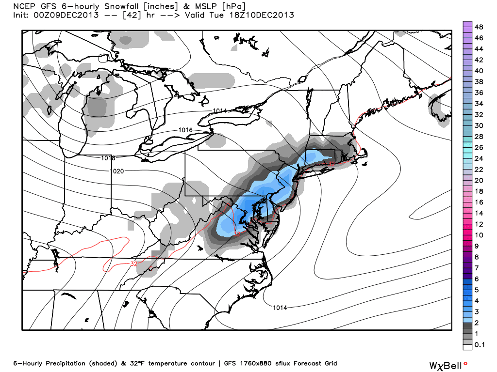
Once this system moves out, another one will quickly follow its heals and bring the threat of more widespread accumulating snowfall amounts. Granted, this would be a quick moving system, but it has the potential to drop an additional 1-3 / 2-4 inches of snow. If the surface low strengthens some, isolated areas around the Tri-State could see 6 inches of snow.

Here is the stripe of snow being shown on the 00z GFS extending from CT into northern VA:


If things still look impressive after the 12z runs later this afternoon, I will release a snowfall map and hold a chat at 9:00 pm EST so we can have discussions on the 00z NAM and 00z GFS runs as they come in. 

The next thing that should be addressed are the cold temperatures set to move into the Northeast and Mid-Atlantic states later in the week. Here is a look at the temperature anomalies map by Friday morning:


-10 to as low as -25 degrees below normal throughout the Eastern U.S. 

Here is a zoomed in look at our area:


COLD ! 

2-meter temperatures (temperatures 2 meters from the surface) are only shown to be in the teens and single digits...


And it's not even the heart of winter! Thus far, we have seen some very impressive arctic air masses that do not seem to be moderating at all as they make their descendant from Canada into our region. 

Temperatures will try to moderate by to normal by the weekend, but we should still stay on the below normal side of things. 

The last thing I wanted to briefly mention without going overboard is the threat of a possible coastal storm next week for the Mid-Atlantic to New England states. 


Some models such as the EURO have been close in showing a potent coastal storm early next week. There is a high chance one does not happen, but there is still an interesting set-up in the pattern that causes me to raise my eyebrow a bit. 

Two pieces of energy will be diving into the eastern U.S. next weekend. Piece #2 like I have labeled on the image above broke off Piece #1 and is digging into the southeastern U.S. These two pieces of energy are going to make an attempt to phase somewhere along the coast. And if they do, you can expect a coastal storm. 

Although there is not a -NAO at this time, there is a strong Upper Level Low that may act as a blocking mechanism to help get these two pieces of energy to phase. 

That, to me, is the key. If that ULL can stay on the models through this week and not try and escape northeast, it could force a phase with those two pieces of energy. There are other factors as well, but we are still too far out to even worry about them right now. Some may say this blog has been written too early,  but I'm not calling for a coastal storm. I am just trying to say the set-up is interesting at the 500 mb level and I could see how one forms. 

Have a great day 

Francesco Paparatto 


Notes:

1. Check out the NJ Strong Weather Forum at www.njstrongweatherforum.com to participate in daily discussions involving the weather, including scheduled chats.