So, it has begun.
Meteorological winter began 9 days ago and it only took those few days to get our fist significant snowstorm of the season around the Philadelphia Metro and southern New Jersey areas. Snow amounts ranged anywhere from 4 to as much as 12 inches in isolated towns in southern NJ.
Today, more snow, ice, and rain is expected in those same areas that got the surprise snow yesterday and some of it could even get as far north as NYC. Not much in the way of additional accumulations should be expected, however.
Once this system moves out, another one will quickly follow its heals and bring the threat of more widespread accumulating snowfall amounts. Granted, this would be a quick moving system, but it has the potential to drop an additional 1-3 / 2-4 inches of snow. If the surface low strengthens some, isolated areas around the Tri-State could see 6 inches of snow.
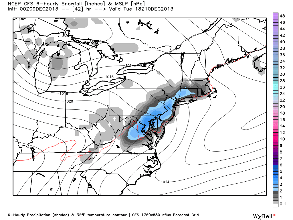
Here is the stripe of snow being shown on the 00z GFS extending from CT into northern VA:
If things still look impressive after the 12z runs later this afternoon, I will release a snowfall map and hold a chat at 9:00 pm EST so we can have discussions on the 00z NAM and 00z GFS runs as they come in.
The next thing that should be addressed are the cold temperatures set to move into the Northeast and Mid-Atlantic states later in the week. Here is a look at the temperature anomalies map by Friday morning:

-10 to as low as -25 degrees below normal throughout the Eastern U.S.
Here is a zoomed in look at our area:

COLD !
2-meter temperatures (temperatures 2 meters from the surface) are only shown to be in the teens and single digits...

And it's not even the heart of winter! Thus far, we have seen some very impressive arctic air masses that do not seem to be moderating at all as they make their descendant from Canada into our region.
Temperatures will try to moderate by to normal by the weekend, but we should still stay on the below normal side of things.
The last thing I wanted to briefly mention without going overboard is the threat of a possible coastal storm next week for the Mid-Atlantic to New England states.

Some models such as the EURO have been close in showing a potent coastal storm early next week. There is a high chance one does not happen, but there is still an interesting set-up in the pattern that causes me to raise my eyebrow a bit.
Two pieces of energy will be diving into the eastern U.S. next weekend. Piece #2 like I have labeled on the image above broke off Piece #1 and is digging into the southeastern U.S. These two pieces of energy are going to make an attempt to phase somewhere along the coast. And if they do, you can expect a coastal storm.
Although there is not a -NAO at this time, there is a strong Upper Level Low that may act as a blocking mechanism to help get these two pieces of energy to phase.
That, to me, is the key. If that ULL can stay on the models through this week and not try and escape northeast, it could force a phase with those two pieces of energy. There are other factors as well, but we are still too far out to even worry about them right now. Some may say this blog has been written too early, but I'm not calling for a coastal storm. I am just trying to say the set-up is interesting at the 500 mb level and I could see how one forms.
Have a great day
Francesco Paparatto
Notes:
1. Check out the NJ Strong Weather Forum at www.njstrongweatherforum.com to participate in daily discussions involving the weather, including scheduled chats.
No comments:
Post a Comment