
When I look at 500mb height anomalies it is mainly to see where the "players on the field" are. This phrase simply means I am looking to see how certain atmospheric features come together because that will determine the track of the storm. Here we are Wednesday morning and you will notice both the GFS and EURO show the same players. How they handle each anomaly will dictate the track, strength, and duration of this possible storm. The main piece of upper energy - the key ingredient to the storm - is located in the PAC NW. This winter we have been killed by either a progressive flow across the country or an amplified southeast ridge. The anomalous trough south of Greenland will help combat this issue. This ULL will act as our 50/50 Low. It is able to maintain its position instead of tracking into the Arctic because there is a -AO/-NAO block in place. The only difference between both models at this time frame is the GFS has a robust lead energy over the Midwest. This clipper-like system will get absorbed by the 50/50 Low which will help to enhance it.

Fast forward to Friday morning and you will notice both models still have the same general idea. The H5 low closes off near the TN valley and spawns a surface low that tracks north as a result of the rising heights ahead of the mean trough. Once it "feels" the block over southern Canada, it transfers energy and tracks a storm up the coast. The trough off the west coast of the U.S. is key because it helps pump a +PNA ridge that turns the flow from zonal to meridonial. Upper air vorticity is able to dig into the mean trough and begin turning it from positive to neutral then eventually negative.

The 500mb height anomalies look pretty similar at this juncture. Obviously there are some differences but they are relatively minor. Where I see the biggest spread between these two models is when examining 500mb vort maps.
Similarities:
1. Western Ridge
2. Positively tilted trough
3. Lead energy (Clipper) is exiting the U.S.
4. 50/50 Block
Differences:
1. PVA (Positive Vorticity Advection) in the trough is stronger on the GFS.
2. The GFS has a northern s/w over the Great Lakes and the EURO does not.
Analysis:
The GFS may have stronger vorticity embedded inside the trough but I like how the EURO consolidates it more toward the base. When energy is evenly distributed along the trough it signals for a more organized system at the surface. Also, the EURO does not have the northern s/w the GFS has over the Great Lakes. This piece of energy, which you will see in future panels, phases into the mean trough but it further complicates the phase.

Similarities:
1. Western Ridge - though EURO is more amplified with it
Differences:
1. The trough is sharper and stronger on the GFS while the EURO is a bit more positively tilted
2. GFS is beginning to phase in the Great Lakes s/w while EURO has already completed the phasing process
Analysis:
It is amazing to me how the GFS shows a very nice looking trough with tons of upper level energy dug in, but it is the EURO that ends up showing the more potent storm at the surface. There is other reasons for that - such as the 250mb jet streaks - but looking strictly at H5 vort maps one may not think that. The key reason is because the GFS is not handling the upper air energy correctly. Notice the EURO outputs a broadened trough while the GFS is a bit more closed.

Similarities:
1. Closed H5 Low
Differences:
1. EURO has semblance of western ridge while GFS went flat
2. Trough orientation is a bit more negative on the EURO while GFS stays neutral
Analysis:
Come Saturday morning and the EURO is the one that maintains its composure with the overall setup of the storm. The trough closes off and the low slowly tracks up the coast. There is a trough off the west coast which helps maintain a ridge over the center of the country. This ensures the H5 low will not track so easily out to sea. Instead, it has nowhere to go but north since we have blocking in the high latitudes that is slowing down the flow downstream. The block and amplified pattern helps turn the trough from neutral to negative. Meanwhile, the GFS is trying to decide whether the H5 low should remain closed or open. It also kills the ridge which keeps the storm track a bit further east compared to other guidance that have it closer to the coast bringing heavy snow even to inland areas of the northeast.
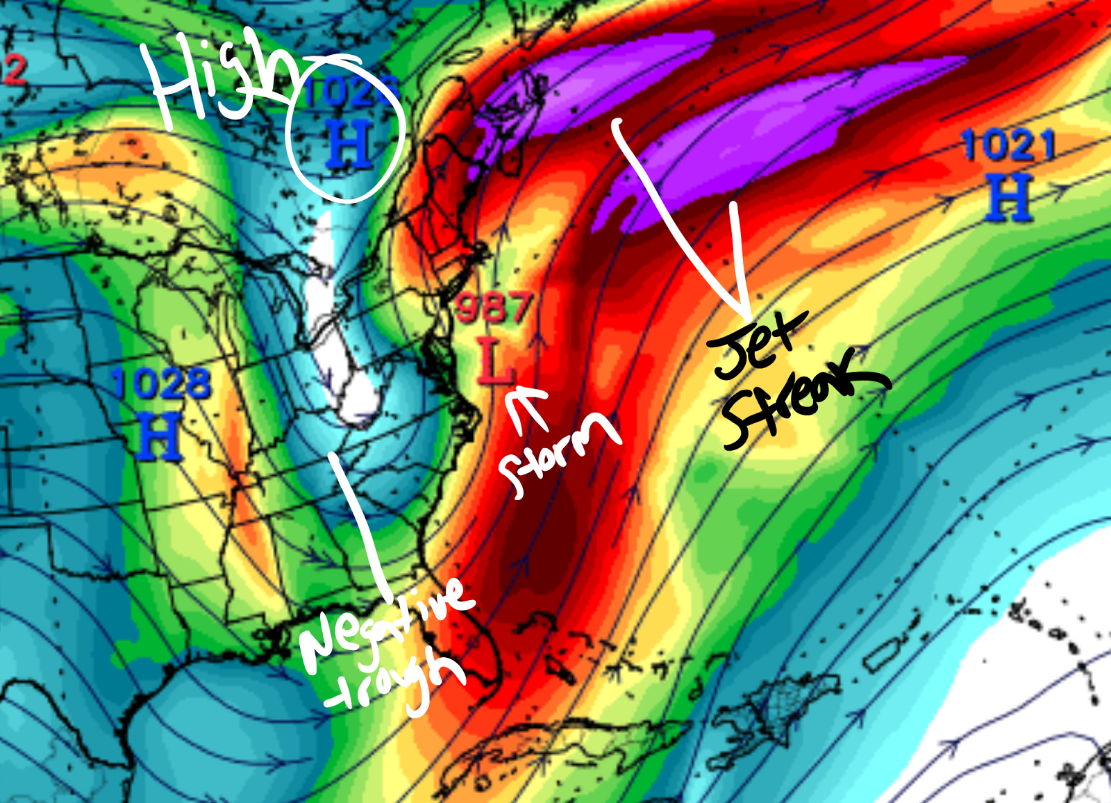
Here is another look at the EURO except this time using the 250mb maps which show where the upper level jet streaks are during the storm. The reason why the EURO has such an expansive precipitation shield, a deep low pressure system, and a track closer to the coast is because of the jet streaks located north and east of the storm. The trough goes negative and the storm strengthens as it does so. A nice High to the north feeds the storm with cold air to pull into the coast.
Storm Track Possible Scenario's


There may be other scenarios that make up a hybrid of the above, but these are the main tracks this system will take. At this time I am not really leaning one way or another. The Pacific short wave we're most interested in is located somewhere over the central Pacific Ocean. I will say there is strong Ensemble support for a storm to track up the coast and the models over the weekend showed great consistency. I would be surprised if scenario #1 comes to fruition and this will happen if the western ridge does not amplify enough and the flow remains fast. However, I think the potent Pacific short wave will raise heights on its own ahead of the trough and the high latitude blocking will slow down the flow downstream enough to track a storm up the coast. The 50/50 Low is also very impressive. I will revisit these scenarios again tomorrow and possibly make a decision of which way I am learning. For now, this is where we stand. The trends over the next few days should be very interesting. The ceiling for this system is it can reach Roidzilla status - which is a 24"+ snowstorm. If this all comes together just right areas could achieve their seasonal snowfall average all in one storm. Amazing.
Have a great week!
Best,
Francesco Paparatto
_________________________________________________________________________________
Follow the forum to get hourly updates:
www.njstrongweatherforum.com
No comments:
Post a Comment