A couple of short work weeks likely ahead for some people as we get ready to celebrate Christmas and the New Year. Unfortunately, the weather over this time period is not expected to cooperate. Several waves of upper level energy are expected to pass over the Northeast bringing a decent amount of rainfall. Temperatures - to the dismay of many - will continue running way above normal for this time of year.
SHORT RANGE - WEEK OF 12/21
In last week's Mo Mo I gave the heads up unsettled weather is likely this week. The rain will come from two waves.

Wave 1 will arrive Tuesday morning. Rain will move in around mid-morning and move out by mid to late afternoon (left image). Wave 2 will be stronger and bring more rain. Rain will arrive mid afternoon Wednesday and linger through early afternoon Christmas Eve. There may be a brief break in the action overnight Wednesday, but moderate rain will return Thursday morning.

Total rainfall Tuesday through Thursday will fall in the 1-2 inch range. Above is the total precip map from the 12z EURO model.

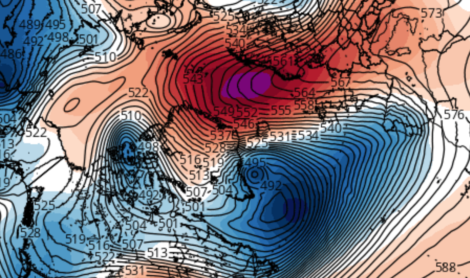
The 500mb height anomaly map on the left nicely shows why we're getting rain this week. Upper level energy associated with the western trough is likely to cut to our west, raising heights along the east coast. Temp departures from normal (right) on Christmas Eve will run +15 to +20 degrees above normal. We've been stuck in this pattern that features a +EPO/-PNA/+AO/+NAO for basically the entire month of December. It will be no surprise to see December 2015 rank as one of the warmest December's ever on record. We'll get the final numbers at the end of next week.

High temps Christmas Eve according to the EURO will range from upper 60's to low 70's. Like last week, it will not surprise me to see NYC Metro surpass 70 degrees.
MEDIUM RANGE - WEEK OF 12/28

A closed off 500mb vort is going to track from the Southwest U.S. into the Northeast beginning this weekend into early next week. Rain associated with this feature will actually begin to move in Saturday the 26th. There is a chance rain could start late Christmas Day, but I think we'll be mainly dry the 25th. Here's how it's expected to play out according to the GFS:

Strong H5 energy will dig deep into the SW CONUS this week allowing heights to rise over the eastern side of the country. Once the 500mb vort closes off, it's going to tap into Gulf moisture which will use the southwest wind flow to stream precipitation into the northeast as early as Saturday.

By Monday the 28th, a surface low pressure system will form in the Southeast then track northeastward into our area. This is being modeled as a very moisture-laden filled system thanks to the Gulf moisture it will be tapping into. Notice the cold air filtering in behind the system. It's not extreme cold, more like seasonable cold.

On Tuesday the 29th, the low pressure system that formed in the southeast will have tracked to the Northeast. Moderate to heavy rain is forecasted with decent winds too. The baroclinic zone and SW flow will work together to keep overcast conditions with on and off rain over our area for a 3-4 day stretch. The main event will arrive on Tuesday. In total, over 2 inches of rain is possible this weekend into early next week.
LONG RANGE - NEW YEAR, NEW PATTERN?

This past weekend Judah Cohen "tweeted" a graphic of expected WAF (Wave Activity Flux) from the GFS model. +WAF, indicative by red shadings, means vertical wave energy usually in the form of Rosby waves is taking place between the Troposphere and Stratosphere. This helps weaken the Stratospheric Polar Vortex. A constant bombardment of +WAF could displace or even split the PV, which would lead to dramatic changes of our pattern at the Tropospheric level usually in the form of a -AO. Wave forcing is taking place as we speak. Another one, as Cohen stated, is expected to occur in early January.
One reason why we're seeing increased WAF over the next two weeks is because of an anomalous Scandinavian ridge forecasted to develop this week. Above normal heights over northern Europe - extending into the Arctic and Greenland - is commonly known as an east-based -NAO. This form of blocking does not have a very big impact on our sensible weather in the eastern CONUS, but it does force an energy transfer into the lower Stratosphere.

The GFS is forecasting the PV in the lower Stratosphere (50mb) to split before the New Year. This is an example of how certain Tropospheric features - such as the Scandinavian ridge - can have a direct influence on the Stratosphere. Specifically, increasing wave forcing (in this case wave 2) between both layers of the atmosphere. This type of image should make winter weather lovers very happy. However, I was reminded by knowledgeable Meteorologist's we want to see this type of bottom-up warming propagate into the upper Stratosphere as well.

While 50mb is expected to split the PV, the same cannot be said from 30mb on up. While the core of the PV is shown to elongate, it does not fully split. Instead, by the start of the New Year it re-consolidates over the North Pole. Keep in mind these type of forecasts tend to change. Perhaps once models latch onto the fact we'll see increased WAF to start the New Year, they'll begin to show greater influence in the mid and upper Stratosphere. We want to see SSW (sudden stratospheric warming) occur in all levels of the Stratosphere to ensure the PV gets displaced or split.

Just because the Stratosphere is not forecasted to undergo full-scale SSW (yet), it does not mean we won't see changes happening in the contingent U.S. The EPS, or EURO Ensembles, New Years week show pretty much the same pattern we've been in all month. Most impressive on the above map is the aforementioned Scandinavian ridge. Other then that...all is the same with awful looking teleconnections bringing record warmth to the east. As stated, this is the pattern you can expected the week of New Years. The ball drop New Years Eve should be dry with temps around normal. I'll have the specifics in next week's Mo Mo.

Drum roll please...
The EPS to start 2016 suggest a new pattern will unfold. Positive height anomalies are shown to amplify into the western U.S. (+PNA) with a trough shown to settle into the eastern U.S. The EPO and NAO still look to remain positive, but there should still be colder than normal air over the east at this time thanks to positive heights extending into the Arctic (east-based block!) The MJO at this time will be out of the phase 5/6 warm phases and could possibly reach phase 7 if the wave does not die off. This means favorable tropical forcing will take shape and the trough over the western U.S. will finally become a thing of the past.
This is definitely a step in the right direction. Turning our PNA from negative to positive will help driver at least seasonable air into the eastern U.S. The next step will be to see the positive heights extend more poleward, into the EPO domain. This will not happen until the Aleutian trough develops. You can see the EPS are hinting at the Aleutian trough developing, but it's still too early in the process.

The steady decline of the AO around New Years is a result of the Scandinavian ridge extending positive heights into the Arctic. Unfortunately, this looks like a temporary feature. Until the Stratosphere undergoes full-scale warming, the AO will continue to average positive. Fortunately, there are signs a SSWE is not far off from happening. I'm not going to get too excited until I see it with my own eyes, though...
The last piece of the puzzle to fall will be the NAO. It's possible the NAO does not go negative at all this winter. Even the last couple of SSWE's in recent winter seasons have been unsuccessful in helping our NAO go negative over a sustained period of time. The northern jet stream has acted very "La Nina" like (progressive flow) which has proved to be difficult to stop. That said, there are decent analogs that show El Nino seasons that undergo SSW usually follow with a developing NAO in the second half of the winter season. As long as the SSWE occurs, we'll at least have a chance to see a -NAO. A -NAO does not mean the east will not see sustained periods of wintry weather. After all, the last couple of winter seasons have been very cold and snowy.
I decided to go against putting out an "official" pattern change timeline. Once I realized the SSWE is only taking place in the lower Stratosphere and not propagating into the mid and upper levels, I knew we still had work to do in that department. I'm feeling optimistic that by next week I will be able to release an official pattern change timeline. I have a good idea right now, but I rather hold off another week until I have all the good information and details.
Have a blessed Christmas and a Happy New Year.
Best,
Francesco Paparatto
No comments:
Post a Comment