Sunday, December 13, 2015

12/11/15 Mo Mo: "Eastern U.S. Roasting On An Open Fire"

"...Jack Frost nowhere to be found"

Am I the only one who is struggling to get into the Christmas spirit because of the weather? No matter how many Christmas movies I watch or songs I listen to, I cannot grasp the fact December has felt like September. We're expected to remain in this pattern through the end of this month. Let's see what the weather looks like over the next two weeks before discussing the long range.

Short Term - Week of 12/10


Temperatures will continue hovering around 60 degrees for the next few days. Another storm cutting to our west will be responsible for bringing rain to our area later today. Look for rain to start falling in the mid-afternoon hours and persist through the evening. Areas of dense fog is also possible. We'll clear by Tuesday morning. Between .25" to .75" of rain is likely. 


Another shot of rain is expected Thursday. Models are indifferent to the intensity of the cold front. The GFS has a strong surface low riding along the front and enhancing rainfall over our area, while the EURO is a bit more progressive. Either way, another .25" to as much as 1.00" of rain is possible Thursday afternoon into the evening. 


Between 1.00" to 2.00" of rain should fall between both storm systems this week. Above is the GFS total precip map ending Friday morning. The heaviest axis of rain will be located depending on where the surface low on Thursday tracks. Central-Southern NJ and areas N&E are a good bet to see the heaviest rain this week. 


Maybe this will help bring some Christmas spirit. Behind the cold front Thursday, a rush of cold air is expected to filter into the central and eastern U.S. The main reason behind this cold air is a sub 940mb cyclone over the Bering Sea helping to pump up heights in the EPO domain. As higher heights extend into the Arctic it helps force a deep trough to track into the U.S. 


According to the EURO, high temps will only range between the upper 30's to low 40's across the area Saturday and Sunday this weekend. This 2-day wonder is not going to last unfortunately. The pattern is still progressive and the trough is quickly replaced by a ridge. 

Medium Range - Week of 12/20


Christmas week is not looking "christmasie" for the eastern U.S. Once the trough from the weekend lifts out, a ridge is expected to build back into the east. The reason behind this is yet another anomalously deep trough getting entrenched into the southwestern U.S. 


A surface low will spawn within the trough next week and cut to our west. A cold front will develop and approach our area on Christmas Day. The timing of how this all comes together remains unclear. I am confident the surface low will cut to our west - bringing more warmth and rain - but the timing of when it happens looks to be anywhere from Christmas Eve to Christmas Day. 


Yesterday afternoon's GFS run suggested the cold front will reach our area in the early afternoon hours on Christmas Day. 50's and rain on Christmas? Man, Mother Nature must have something personal against us if this is the case. After Christmas Day we'll see a day or two of average to below average temperatures and then another warming period is expected the week of New Years. If you're a winter weather lover, by this point of the reading you're probably ready to "cancel" winter and declare it a lost season. I am not ready to join your clan because I knew coming into the season we will start off warm. 

Long Range - Where Oh Where is the "Pattern Change?" 

The current and foreseeable pattern features a +EPO/+AO/+NAO/-PNA. All of these signals are in the wrong phases if you're looking for sustained cold / wintry weather. The reasons behind these unfavorable signals are due to MJO/Kelvin Wave disruptions and the anomalously cold Stratosphere. Let's start by checking on SSTA trends of each Nino region. 


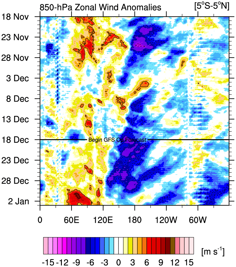
Each Nino region over the last week or so has experienced cooling of SST's. The bold line is Nino region 3.4 and it's evident SST's in that region have been on the decline. Looking at zonal wind anomalies, it looks like easterlies are taking over east of 120W and the WWB's (westerly wind bursts) around the International Dateline (180) are weaker in magnitude. It's very possible El Nino has peaked. If this is true, the ridge over Canada should begin to retrograde west over time which will allow a trough to undercut and form over the southern and eastern states. How quickly this ridge move from eastern Canada to western Canada will determine how many week of winter weather we'll experience in the east. I expect by mid January the CA ridge will be centered in west-central CA and for the Aleutian trough to further south & west allowing higher heights to enter the EPO domain. 


The MJO over the last several weeks has been in phases 2-3-4. The increased MJO wave activity is not usually common during El Nino episodes. Larry Cosgrove, a respected Meteorologist, mentioned areas that should be seeing enhanced rainfall typical of El Nino seasons (California through southern tier of U.S.) have actually been relatively dry while the Pacific Northwest has been seeing storm after storm. An MJO in these phases means tropical forcing is taking place over the Indian Ocean (see below graphic) which signals warm weather for the central and eastern portions of the U.S. 


Looking at 200mb zonal winds across the Equator we see negative anomalies exist between the Dateline and 120W (blue shading). Positive anomalies are shown west of 180 into the Indian Ocean. This usually means OLR anomalies are negative over this region and tropical forcing should be favored to promote cooler weather over the central and eastern U.S. However, active MJO and Kelvin waves have interrupted +ENSO forcing (El Nino) and the atmosphere is not able to respond to what is usually seen under these conditions. 

The EURO model suggests this current MJO wave could get into phase 7, albeit it's a very weak signal. If it manages to propagate east and maintain its strength it's possible we see colder weather arrive to the eastern U.S. after Christmas (closer to New Years). 

Stratosphere
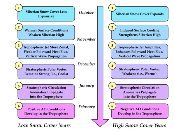


Some of you are probably familiar with this chart. Judah Cohen put it together to show how above normal (or below) snowfall in the month of October leads to a -AO (or positive) to develop. We're focused on the right side of this chart since Eurasian and Northern Hemisphere snowfall finished above average at the conclusion of October. According to Cohen poleward heat flux or vertical wave propagation, in the form of Rosby Waves, should have fired from the Troposphere into the Stratosphere during the month of November to aid in weakening the Stratospheric Polar Vortex. We're almost in mid-December and we've seen just 1 wave attack so far. 


A wave 1 attack occurred in late November around Thanksgiving. This attack temporarily weakened the Polar Vortex but it was not enough to displace or split it. A second wave 1 attack is expected in the next 5-10 days. EPV is a good measure of vertical forcing through the Troposphere and Stratosphere. I went over this a couple of weeks ago, but it's worth repeating, the more poleward and longer the arrows the better the odds are of the PV weakening. 


Looking at 10hPa heat flux, the orange line nicely shows the next wave 1 attack. However, the problem is the magnitude of this attack is similar to the one we saw in late November. We need to see these attacks be stronger and more frequent in nature or else the Strat. PV will continue to reform over the Arctic Circle. 


The current state of the PV from the CFS is seen above. The PV is nicely wrapped up in the Arctic Circle. Its shape and overall structure points to a powerful vortex that will take several strong Tropospheric wave attacks to either displace it out of the Arctic or split the Vortex into two.  


By week 2, we're able to see the next attack which the wind & flux chart is accurately predicting. A strong 10mb ridge is located near the Aleutians allowing higher heights to penetrate into the Arctic Circle. The elongated-looking core of the PV suggests it's clearly feeling the effects of this warming event but guidance insists this will be temporary. 


Come week 3 - News Years week - the PV is back to its strong state as the warming wanes. If you look back at Cohen's chart, he says in January there should be Stratospheric circulation anomalies propagating back into the Troposphere. We're not quite at that stage yet until the PV weakens to levels where it begins to have an effect on our sensible weather in the Troposphere. 


I find this graphic to be slightly interesting. The CFS feels by week 4 another warming event will take place. While 10mb temps do not look impressive in this image, the location and structure of the PV suggests this could be the strong wave 1 warming event we've been waiting for. The time frame to watch for this possibility to happen is the 1st week of January between the 3rd and 10th. I strongly feel a SSWE is still likely to occur due to the state of the QBO. It's looking likely this will happen between January 6th to the 13th with effects reaching the Troposphere later that month. 

The way the pattern is evolving this year may be frustrating to some. When we're dealing with a strong El Nino AND Stratospheric Polar Vortex, it's going to take time for change to happen and for our atmosphere to favorably respond. Interestingly enough, El Nino reaching its peak and the Stratosphere undergoing a SSWE (Sudden Stratospheric Warming Event) seem to be on pace to happen at the same time. If this is true, our sensible weather could completely change from one week to the next sometime in late January. I am still expecting February and March to feature below normal temperatures and above normal snowfall for NYC Metro. 

Thanks for reading! 

Best,

Francesco Paparatto
_________________________________________________________________________________
Join the forum: www.njstrongweatherforum.com 

Follow me on Twitter
Follow me on Facebook


Monday, December 7, 2015

12/7 Mo Mo Blog: December Warmth & Christmas Forecast

Today's Monday Morning update will look at our weather over the next two weeks. I will also give you my initial thought's on the Christmas forecast. Am I dreaming of a white Christmas? 

Short Term - Week of 12/6: 

There is not much going on this week. In last week's Mo Mo, I mentioned there is a possibility of a Nor'easter to effect our area Tuesday-Wednesday this week. The pattern does not support one. 

18z GFS 500hPa Vorticity valid 1am Tuesday: 


500mb vorticity is a useful tool that measures the amount of "spin" in the atmosphere. I often refer to it as upper level "energy" or "short waves" that (if positive advection) can lead to surface low development (surface low = an actual storm). Notice the potent level of vorticity I circled over our area Tuesday morning. The reason why there is not a deep low pressure system sitting off our coast at this time is because the overall flow is not amplified, meaning you see no trough's or ridge's on a 500mb map. The very weak / disorganized trough along with the fast flow is the main reason why this Nor'easter will not happen. Instead, we're likely to see clouds with light rain showers. 

Expect temperatures to be in the low to mid 50's the entire week other then Tuesday. In fact, they'll be even higher come the weekend.

18z GFS 500mb Vorticity valid 1am Sunday the 13th 


A trough axis with very strong vorticity embedded is expected to be located over Texas this weekend. A surface low pressure system will form and track somewhere between Indiana and Western PA. The end result for our area will be much above normal temperature departures thanks to the High Pressure sitting off the east coast helping to pump up mild Gulf air from the Southeast.

12z EURO temp anomalies valid 1pm Saturday


The process I explained above actually takes place sooner than Sunday. The troughing will take shape over the western U.S. beginning Friday. This means positive heights are expected to take over the central and eastern U.S. Friday through the weekend. The EURO is advertising temperature departures of 20* to as high as 30* above normal from TX to eastern Canada. I would not be surprised to see NYC reach 60 degrees both Saturday and Sunday this weekend. Meanwhile, the western U.S. continues to see cold temps and frequent snowstorms. 

Medium Range - Week of 12/13: 

12z EURO 500mb height anomaly valid 7am Sunday 12/13 


This graphic is intended to show another perspective. The 1st system over Texas leading to the ridging over the eastern U.S. is the one I just finished talking about. By Monday the 14th, the cold front associated with this storm will reach our area (it's possible the timeline gets moved up to Sunday) to bring heavy rain and possibly high winds. I do not buy into the high wind forecast yet but I do think we'll see decent rain next Monday.

The 2nd system entering the Pacific Northwest should bring more rain to the area Thursday-Friday (17th-18th) next week. I will speak more about this system in next week's Mo Mo. 

Long Term - Initial Thought's on Christmas:

12z EURO Ensembles 500mb height anomaly valid 7am Wednesday 12/16


Keep in mind when looking at these images model verification's in the long range are not great. That said, we seem to be in a persistent pattern that does not intend on changing anytime soon. The EPS suggest the western U.S. will continue to get inundated with upper level trough's, or colder than normal temperatures, while the east stays average to slightly above. Part of the problem is the cold moderates as it travels east. The Alaskan Vortex prevents the Pacific ridge from amplifying into the EPO/PNA domains so the flow remains flat and fast. 

12z EURO Ensembles 500mb height anomaly valid Saturday December 19th


The EPS show no change as we head deeper into December. This is also in line with what the EURO Weeklies are showing. Over the past weekend, the GFS OP and GEFS seemed to take a step in this direction as well. At one point, the GFS OP was really overdoing the cold weather across the U.S. Given the strong El Nino regime we're under, in conjunction with an unfavorable Stratosphere and Tropical Forcing, this is not surprising to me. I predicted December to be warmer than normal given the historical nature of strong El Nino's in west-based QBO years. It's going to take time for Nino to weaken to moderate levels. Once it does, the Sub-Tropical Jet Stream will not be the dominant force in our overall pattern. 

I spent a good amount of time in last week's Mo Mo analyzing the current state of the Stratosphere. I do not want to spend as much time again this week, but do want to point out that the upper Stratospheric warming guidance was showing a couple of days ago does not look as impressive in the recent runs. 

Here is what the OP GFS showed this past Saturday afternoon at 10hPa:


Now here was Sunday afternoon's run:


Noteworthy:

1. The magnitude of the ridging or warmth over Siberia is not as strong
2. As a result, the core of the PV is not as elongated / displaced 


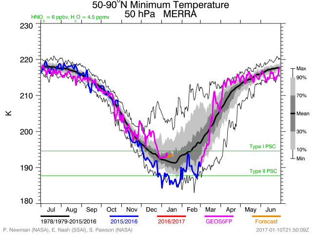
Temperatures at 50hPa (mid-Stratosphere) are running colder than normal (normal = solid black line) and are forecasted to get even colder this week. This indicates the PV remains strong and well organized. It will take a couple of potent warming events to weaken it to a point where it has an effect on our weather at the Troposphere. 


It's also worth mentioning the MJO is forecasted to go into phases 3-4. The convection we saw these last couple of days over the Dateline is expected to propagate west toward the western Tropical Pacific while the Indian Ocean continues to see frequent thunderstorm activity. Historically, an MJO in phase 3 during El Nino years result in the following 500mb map:


It's not a perfect match to what current guidance is showing in the long range. The general idea is correct with positive heights over central / eastern U.S. and Canada. while also showing the western U.S. trough. Overall, MJO influence in strong El Nino years is not as strong as ENSO neutral or La Nina regimes. It's not one of the signals I'll be paying much attention to this winter. 

Christmas Forecast:

I will likely update this forecast in the week's to come, but my initial thought's are it will be average to slightly below average Christmas Day. Depending on where the baroclinic zone sets up, I can see how a winter storm effects our area. However, in order for the baroclinic zone to be south & east of us, we'll need to see either a -EPO or +PNA begin to show up on the models. The odds of one of these features developing in this locked in pattern is pretty slim. The reason why I am leaning below normal is because the two low pressure systems expected to cut next week could create "traffic," or confluence, north of us that prevents a tertiary low from cutting. Instead, a weak trough could settle in over our area. By next week we'll be able to see what some of the long range models are showing. Right now, none of the major global models are in range. 

Thanks for reading. Have a great week! 

Best,

Francesco Paparatto 
________________________________________________
Join the forum: www.njstrongweatherforum.com 

Follow me on Twitter
Follow me on Facebook


Monday, November 30, 2015

11/30 Mo Mo: Winter Update

Today's Mo Mo blog is going to give you an update on how the long range pattern is looking heading into Meteorological Winter. 

Buongiorno,

I hope everyone had a nice Thanksgiving break. Hard to believe Christmas is a short few weeks away. It sure did not feel like Christmas these last few days or even weeks. Temperatures have been averaging well above normal. This looks to continue into the first couple of weeks of December which is not surprising under a pattern driven by a strong El Nino. 

SHORT RANGE - Week of November 29th

I do not want to spend too much time speaking about short term weather. Expect gloomy and rainy conditions Tuesday and Wednesday this week. A low pressure system will cut off to our west sending mild Gulf air and moisture northward into our area. 

Anywhere from half an inch to one inch of rainfall is likely. The weather will clear by Thursday and temperatures will also take a dip into the mid to upper 40's. Temps will hover around 50, plus or minus a few degrees, into the weekend with clear conditions expected. 

MEDIUM RANGE - Week of December 6th

Another storm system is expected to impact the area exactly 1 week from this week's storm, approximately Tuesday December 8th into Wednesday December 9th. 

12z EURO 500mb vorticity / heights valid Monday December 7th:


As of this moment, the EURO and GFS models are in fair agreement of a storm cutting off well to our west again. What is different with this system compared to the one we'll get rain from this week is the low pressure system does not track into Chicago and the Great Lakes. Instead, it tracks into the Northeast. It's likely to cut North and West of I-95 which will send warm air advection into the coast. Normally a storm track this time of year NW of I-95 could bring wintry weather to the interior Northeast, but with the Polar Jet forecasted to be in central Canada (2nd image) there is no cold air to be found. Additionally, we're probably looking at increased rainfall amounts with this system in excess of 1 inch. However, storms have trended weaker / drier this year so we'll see how we look by next week's Mo Mo blog. For now, expect more rain and mild temps early next week too. 

LONG RANGE - Winter Pattern Update

With Meteorological Winter beginning Tuesday (Met Winter is Dec 1st to Mar 1st),  I figured it would be a good time to check up on the pattern. Please give my Winter Outlook a read if you have not already so you have an idea of how I expect the winter pattern to progress through each month. 


SSTA's in the Pacific still shows a raging El Nino over the Equatorial Pacific and a +PDO, defined by the above normal SSTA's in the Northeast Pacific Ocean. 


ENSO tracker of each Nino region from StormVista over the last month suggests El Nino has strengthened through November. As of last week, the ONI value for Nino region 3.4 was 3.1*C. To put that in perspective, not even the Super Nino of 1997-1998 saw an ONI value get that high. Averaged over the entire winter 1997-1998 is lijely still to come out on top. The reason why there's a bit more optimism surrounding this winter if you're a winter weather fan is because most forecasters, including myself, believe this El Nino event will peak / weaken sooner than the 97' event. As Nino weakens, so does the Sub-Tropical Jet stream thus allowing the Polar Jet Stream to have more influence on the overall pattern (i.e. driving cold air into the central & eastern CONUS). 


The image on the left is a 500mb height anomaly composite of +PDO and strong El Nino years for the month of December (thanks to Isotherm for pulling image off the ESRL site). In case you can not read the years, they are: 1957, 1965, 1982, and 1997. On the right is the forecasted 500mb height anomalies in the 8-10 day range from the EURO and GFS models. The yellow circles are intended to easily show the similarities between those strong El Nino December's and our upcoming December pattern. What's most common between these three images is all agree on the placement of the Alaskan Vortex, which keeps the EPO positive and helps spread mild Pacific air into the country. Therefore, it's not a surprise my Winter Outlook along with many others called for a warm start to the Meteorological Winter. The million dollar questions are:

1. When does El Nino peak? 

2. When does the Alaskan Vortex retrograde to the Aleutians and promote ridging into the NE PAC and western U.S.? 

3. When will the AO and NAO go negative, if at all? 

Let's start with #1. One way I like to tell if the current El Nino is close to peaking is by evaluating the state of the trade winds and monitoring the trends of ONI (Oceanic Nino Index) in each Nino region (there are 4 of them) over the last month or so. 


The CFS forecast (solid black line is present time) is predicting a series of Kelvin Waves (purple) and Rosby Waves (green) to intersect over the International Dateline (180). I circled where that is expected to happen for a visual understanding. 


If we overlay OLR (Outgoing Longwave Radiation) onto the same map, we notice negative anomalies showing up between 180 and west of 120W which points to convection, or enhanced thunderstorm activity, to continue over that area. This promotes tropical forcing which could eventually lead to transient ridging over the western U.S. within the next 2 weeks. 


Taking the equatorial waves into consideration as well as the OLR forecast from the CFS when looking at 850mb zonal wind anomalies, it's no surprise strong WWB (westerly wind bursts) are expected over the International Dateline and just west of 120W. This is an indication winds will shift from blowing east to west (normal state of winds over the Equatorial Pac) to west to east and that will help transfer warm water to the central ENSO regions. Additionally, the blue shadings east of 120W suggest easterly winds to persist over the east-central and eastern-most ENSO regions. This is a pretty good indication temperatures will / already have stopped warming over Nino regions 1+2 as there is no mechanism for the warming to continue.
While the easterlies are a promising sign Nino regions 1+2 and possibly 3 have stopped warming, it remains to be seen if that's the case for Nino region 3.4. These charts suggest there is still room for additional warming but notice the amplitudes of these WWB's are not nearly as strong as they were in October and early November. The latest ONI values have not been released yet. Once they are, I will be sure to provide everyone an update on the forum. They will give us a good indication if we've finally reached a peak. I do believe there's still room for the central / western Nino regions to warm given the state of the MJO and trade winds, but a peak should come by early to mid-December which puts us in a pretty good place for the 2nd half of winter. 


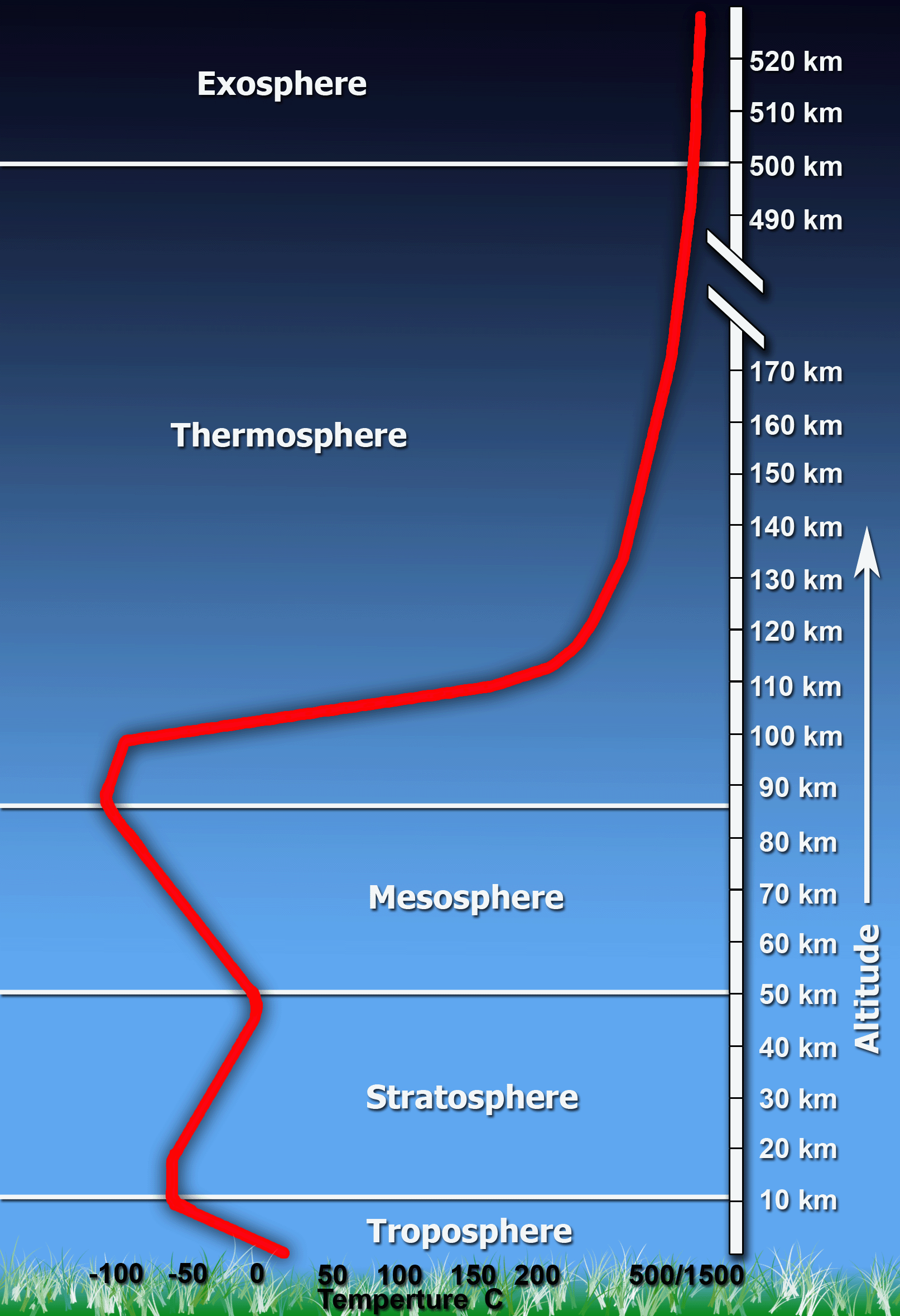
Other then studying ENSO and Pac/Atl SSTA's, we can also analyze the Stratosphere, the layer of our atmosphere just above the Troposphere. One specific activity we look for is known as Sudden Stratospheric Warming Event (SSWE), which is when temperatures in the Stratosphere warm to rapid levels in a short period of time. The end result, no matter how we got there, is either a displacement or split of the Stratospheric Polar Vortex. As a result, this weakens the Tropospheric PV and allows it to move out of the Arctic into the southern latitudes of Canada. This typically, but not always, takes the AO from a positive phase to a negative one and allows cold air to filter from the Arctic into central / eastern Canada and eventually the U.S. 

Talking about the Stratosphere is an area of Meteorology I am still getting to understand. I know the basics of how certain wind patterns in the Polar Stratosphere, typically measured by the QBO, can impact our weather in the Troposphere (layer of atmosphere where we live). That said, much of the discussion that will take place is broad-based and high level.


A current look of temperatures at 10hPa in our Stratosphere shows it to be very cold. Between 10hPa and 30hPa is typically known as the "middle Stratosphere" and is exactly where we want to see warming take place. Notice how expansive the colder than normal temperatures are which is an indication this years' Polar Vortex in the Stratosphere is very strong. 


Here's another graph showing temps at the 50hPa level. Notice how much colder 2015-2016 is compared to last season (solid blue line) and the mean (solid black line). By now you understand the Stratosphere is COLD and we need to see it warm up if we want it to influence our PV in the Troposphere. On a side note, it's not surprising to some the Stratosphere is running colder than normal. The QBO, a measure of Stratospheric Winds, is currently in a positive state which means westerly winds. Historically, westerlies strengthen the Stratospheric Polar Vortex. The 30mb QBO value for the month of October was +13.38. Not anomalously positive but positive nonetheless. 

Heat Flux helps us understand wave forcing (wave 1 and wave 2) while Momentum Flux points to their meridional (north-south) state. The intensity and duration of wave 1 or wave 2 forcing often tells us if a SSWE is taking place. The best way to explain "wave 1" and "wave 2" is by counting the ridges and troughs in geopotential heights around the world within the latitudes that the Stratosphere is located in. Wave 1 forcing typically points to PV displacement while Wave 2 signifies PV split. 


This graphic shows Geopotential Heights and Temperatures at 30hPa level at 216 hours from the EURO. It's forecasting the Stratospheric PV to remain strong with little to no wave 1 forcing (or warming) taking place.  


A look at EPV, or Eliassen-Palm Vectors, represent vertical forcing that takes place through the Troposphere into the Stratosphere. The direction (look at the arrows) and magnitude (size of the arrow - how far north along the Y-Axis they extend) tells us if vertical forcing exists, and if so, how strong it is. The further north, or poleward, the arrows are pointing the better it is for Polar Vortex weakening. We had a minor event before Thanksgiving but given the EURO forecast we just saw it clearly had little to no impact on the PV. 

The conversation with the Stratosphere extends way more than what I just talked about. However, these are the basics and as of now they show a very cold / strong Stratospheric PV. Until this changes, our AO and NAO will remain positive and the strong El Nino will continue being the dominant force in our overall weather pattern. Something I should mention which is pretty important is the above normal Eurasian SAI (snow advanced index) should lead to increased energy interaction between the Troposphere and Stratosphere in the form of latent heat release. Once High Pressure takes over in Siberia and temps gradually warm, the melting process should send "heat" into the Stratosphere and possibly begin the process toward a SSWE. There's another dimension to this - which I am still learning about - that consists of Rosby waves and their interaction with land masses (mountain torque) that could also effect the rate in which our Stratosphere warms. 

It will be interesting to follow the Stratosphere in the weeks to come. Historically, strong El Nino events deliver SSWE's between end of December to mid-January. The earlier the better for our winter prospects. 

CONCLUSION 

1. Rain Tuesday and Wednesday this week with above normal temps early then falling back to average for a couple of days. 

2. More rain likely early next week with above normal temps expected to last. 

3. Possible shot of cold air mid-month thanks to the tropical forcing taking place over the Dateline. More to come of that in next week's Mo Mo. 

Fino la prossima volta (until next time), 

Francesco Paparatto 


_________________________________________________________________________________
Join the forum: www.njstrongweatherforum.com 

Follow me on Twitter
Follow me on Facebook


Monday, November 23, 2015

Mo Mo Update: November 23rd

Good Morning, 

For those who are not familiar with these Monday Morning (aka "Mo Mo") blogs, I decided to put one out every Monday morning to highlight the upcoming weeks weather and a bit of the long range. This week is especially important because it's one of the busiest travel weeks of the year. Thanksgiving! 

Short Range

The first few days of the week will feature dry weather but some pretty cold temperatures, especially in the morning. High's around the Tri-State area will be in the mid to upper 40's between today and Wednesday with low's in the 20's and low 30's. 


A low pressure system developed off the coast yesterday. The baroclinic zone remained well offshore keeping precip out to sea. As the storm moved north into extreme eastern Canada, a trough sneaked in behind to settle over the northeast. Notable by winds shifting to the northwest allowing to transfer cold air from Canada into our area. 


Here is a look at what the EURO is predicting for temps valid 7am Tuesday (left) and Wednesday (right) morning. Both images show temps in the upper 20's to low 30's, which is pretty cold for this time of year. 

Thanksgiving Day


500mb Height Anomalies from the 12z EPS show an elongated ridge over the eastern CONUS. This promotes the southwest flow to take over and bring mild temps into our area, possibly getting into the 60's around NYC Metro! The very fast northern jet boots out the High Pressure that was there earlier in the week to our north which would have helped combat winds from turning to the south. This gives the deep anomalous trough over the west more power to raise heights over the east coast. 


It is also looking like a dry week and Thanksgiving is expected over the eastern U.S. High Pressure is in control until we get to early Saturday morning. A weak cold front will come through bringing little to no rain while also taking temperatures back down to average.

December 1st Storm? 

The EURO and GFS suggest there will be an east coast storm to track on December 1st. The question on everyone's mind of course is will there be snow associated with it? Let's check out the upper air pattern.


The Sub-Tropical Jet is once again looking to rear its head. Of course, that is not surprising given the strong El Nino we have going on over the Tropical Pacific. The above is the 12z EPS showing the ridge axis over west-central Canada and a weak trough over the east. The deep trough over the Aleutians is impressive but centered a little too far east. This disallows the PNA from going positive while shunning the Canadian ridge east. Right away you'll notice there is not a cold air source to work with. A lot of the cold that is over our area at this time is moderated or antecedent from pieces of energy that break off the Aleutian trough and travel east. As long as the ridge axis is over central Canada and the AO is positive, it will be difficult to get an arctic express connection from Siberia into the eastern U.S.

The GFS cuts the storm to our west while trying to transfer energy to the coast. Boundary layer temps warm up in this scenario which would promote rain for most across the northeast. The EURO keeps the 500mb vort far enough south that by the time a phase occurs the surface low is right on or just off the east coast. In this scenario, wintry weather has a chance to impact areas all the way to the coast. As the storm deepens, it pulls cold air to the coast and changes rain to a heavy wet snow. Dynamic cooling plays a big role in this event since we're not working with an arctic air mass. 

At this time, I'm not a believer in the EURO scenario. I give more credence to the GFS trying to cut the primary low to our west. I also feel that if the storm did decide to take a EURO route, it has a good chance of going out to sea. The ridge axis is too far east for my liking and the flow over the east looks too fast for any storm to get organized. If the EURO maintains its position over the next couple of days then I will take it more seriously and look further into why it has a chance to be right. 

Long Range


The top image is of the 12z EPS valid December 7th and the bottom is 12z GEFS for same time frame. We are looking pretty far out so take both these representations of 500mb heights with a grain of salt, but this looks pretty close to what I was thinking for December when I created my Winter Outlook. Initially this may look warm with all the reds and oranges, but the heights over the eastern U.S. are fairly neutral on both pieces of guidance. The warmest temp departures are in central and eastern Canada with slightly above normal across northern New England and upper Midwest. The Northeast and Mid-Atlantic are near normal. Like I said earlier in the blog, any cold air masses getting into the northeast are likely moderated because of the large Canadian ridge. 


If we look at the latest run of the CFS American Seasonal model and what it had for December regarding 500mb heights anomalies, you cans see it's pretty close to what the GEFS and EPS are showing. Aleutian trough, Canadian ridge, +NAO, and biggest departures over central and eastern Canada. 

With guidance in fair agreement, I am expecting December to go as planned with temps finishing above normal for the area when all is said and done. There is no wintry weather on the horizon anytime soon, though the December 1st threat bares watching still. 

Next Monday, we'll look at the state of our Stratosphere, progression of El Nino, and an update to latest long range guidance. We'll also have a clear idea of what our sensible weather will be on December 1st. 

Enjoy your week. I wish everyone a Happy Thanksgiving. 

Take Care,

Frank