Wednesday, August 13, 2014

Random Thoughts As Summer Dwindles Down

This is the time of year when we try to make the best of these last few weeks of summer before the leaves begin changing colors, daylight gets shorter and shorter, and the cool weather is back to remind us the holidays are not too far away. Speaking with many different people this summer, everyone seemed to agree it has been fantastic weather-wise. Not too hot, not too cold. Rain seems to come during the week and the weekends have been gorgeous. Here are just a few random thoughts I have on the weather going forward:

1. Yesterday into this morning was pretty unbelievable for coastal NJ into central and eastern Long Island. An upper level low located north of the Great Lakes was acting as a pivot for a secondary coastal storm that developed on top of NJ. With that secondary low came a tremendous amount of convective rain that dumped nearly a foot of water in some locations in a short period of time. The two low pressure systems were essentially feeding off each other, but the western side of the secondary low was moisture starved so the east side of the secondary low is where the heaviest rain fell. Below you can see the estimated rainfall map.


2. The hurricane season...or lack of I should say. Hopefully none of you are surprised because it was well-documented in the spring that this will be a quiet season due to the emergence of El Nino and relatively cool sea surface temperatures in the eastern Atlantic. The Atlantic Basin is as inactive as the Yankee offense, with only a couple of storms developing close to land. Hurricane Arthur bringing some problems to Hatteras of NC, but for the most part, boring. I do think we will see the Atlantic heat up in September, with possibly 2-4 named storms in the month, but how strong they get and where they travel as a big fat unknown. 


3. A lot of chatter about the 2014-2015 winter season already. From what I have read, most are predicting a "brutally cold" winter with "above normal snowfall" for our area. Oh great! Just what we want to hear, right? Right. The problem is that forecast has a better chance of failing than it does verifying. Predicting both below normal temperatures and above normal snowfall for the NYC Metro area in August is not the wisest thing to do when there are so many unknown variables vital to long range forecasting. Lets take a look at the graphic below. 

The above image shows the sea surface temp. anomalies from January. The bottom one shows the same thing, except for July of this year. Flashback to January and you will remember the negative EPO is pretty much what drove our winter pattern, with ridging over the Aleutians and Alaska into western Canada leading to deep troughs over the eastern U.S. There was little if any blocking in the Atlantic, meaning the NAO was in a mainly positive state so most of the storms were fairly quick movers. 

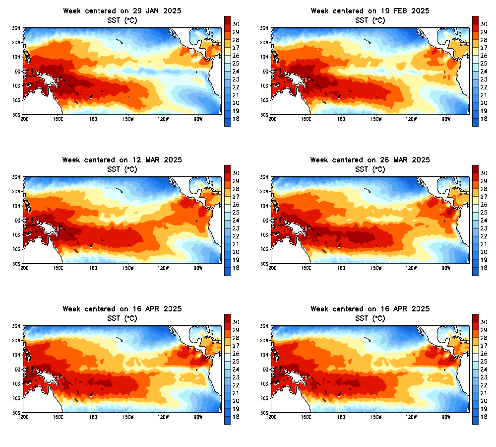
Comparing the two images, we see that the Pacific about 6 months later is much warmer. We are transitioning from a -PDO to a +PDO, the ENSO is going from neutral to positive (or at least trying to), and the warm SST's in the northern Pacific are STILL there. If the Pacific continues this trend and it holds for the winter, we are likely to see plenty of storminess in the eastern U.S. as the STJ (sub-tropical jet stream) becomes active. An active STJ combined with an active PJ (polar jet stream) is likely to lead to an above normal precipitation season. (Note: precipitation is not the same as saying snow!) 

 However, Nino region 1+2 is where the warming is occurring. In order for us to see a true El Nino event come to fruition this winter we need to see region 3.4 warm and that has not happened yet. Will it happen? This is the million-dollar question and one that I think no one truly has an answer to. The CFS model still insists on a weak-El Nino event this winter, as does the NMME model. Here is the CFS.


The SOI (southern oscillation index) forecasts the intensity of El Nino or La Nina events. Sustained SOI values below -8 indicate a healthy El Nino. When you reach -11 or even lower is when the Nino is in "strong" territory. The SOI for July came in at -4.0. In May, it was at +4.0 so it is steadily declining. Problem so far is we are not seeing those warm SST's in Nino-region 3.4 respond just yet. When we do, I think that is when we can strongly consider this upcoming winter of being El Nino. Until then, much of what you are reading on the web is speculation at this point. 

4. I will have much more about the winter obviously in my 2014-2015 Winter Outlook set to be released November 17th. There will be MUCH more to talk about then. Until then, has anyone else noticed how much media attention winter has been getting over the last few years? It has gone from The Weather Channel naming winter storms to media outlets abusing fancy phrases such as "Polar Vortex." Anything to draw in people, I guess. 

Ciao for now. 

Francesco Paparatto


Please join the NJ Strong Weather Forum to participate in daily discussions regarding past, present, and future weather! 


Sunday, July 20, 2014

El Nino Update

Good evening all,

I am going to keep this short and sweet by giving a quick update on the status of the ENSO. Currently, we are still experiencing ENSO-neutral conditions with the latest ONI value in Nino-region 3.4 registering in at +0.3. Remember, we have to reach an ONI of  +0.5 or higher to classify El Nino conditions. If the +0.5 (at least) ONI is maintained for 5 or more consecutive periods (as is usually the case), we can call it an El Nino episode.

My current thinking is the ONI for ASO (August-September-October) will reach the +0.5 threshold. There is still a chance it occurs in the JAS (July-August-September) period, but with the recent development of the current El Nino actually weakening, that may be too far-fetched to say. Additionally, the IRI plumes are only slightly above 50% chance of El Nino for the JAS period, but shoot up to 60% chance for the ASO.


Here is a look at the dynamical / statistical models. You can see why the probability graph favors ASO over JAS by examining these models and when they reach the +0.5 threshold. Focus your attention on the solid black line. 


There are 3 things we would like to see progress over the course of the next 3-4 months to see the El Nino come to fruition by mid-Fall:

1. Trade winds weaken and track east
2. Air pressure fall in the central and eastern Pacific
3. Rise in surface pressure over the Indian Ocean and Australia

Once those things begin taking place, we should steadily see El Nino intensify. 

Sea surface temps are increasing in Nino region 1+2, but we need to see them increase over 3.4 much more. As long as the 3 factors I mentioned take place, we should begin to see this happening. 

Enjoy your summer!

-Francesco Paparatto


Thursday, May 22, 2014

NJ Strong Wx 2014 Summer Outlook

There has been a lot of speculation about the upcoming summer in determining whether or not the projected El Nino comes to fruition. If it does, it obviously will have a dramatic effect on our weather pattern. I thought the best way to approach this blog was by looking at some real-time observations (sea surface temps and ENSO regions) while also taking a look at what deterministic models have to say. Then we can research past years to find similarities and ultimately make a forecast for our summer. Lets get started...


Focus your attention on the 0-degree latitude line (Equator) when you are looking at the SST Anomaly map. Got that? Good. Now I want you to look at the next image:


The ENSO regions are broken into 4 parts and sit along the "Equatorial Pacific." So if you compare, for instance, ENSO region 1+2 with the SST Anomaly map I posted, you will notice there is quite a bit of warming taking place off the northwestern coast of South America.  In fact, there appears to be normal to above normal anomalies in all the ENSO regions. Of course, in case you did not know, when the Equatorial Pacific is experiencing SST's running consistently above normal, that is an indication that an El Nino could be forming. Specifically, most Climatologist go by Nino region 3.4 to determine La Nina or El Nino by looking at the ONI (Oceanic Nino Index). If the ONI in Nino region 3.4 exceeds +0.5 degree C for 5 straight overlapping seasons, an El Nino will be officially declared. 


The CFS certainly insists that Nino-regions 3 and 3.4 will reach El Nino criteria, not just for this summer, but into winter of 2014-2015. But that outlook will not be out until around Thanksgiving. Lets not get ahead of ourselves. 

Just in case you do not buy into the good ol' CFS model, here is the EURO for ya:

Some of those members are getting the ONI as high as +3-degree C (anomaly). The mean, however, looks to be around +1-degree C (for the summer). 

To what extent has the Equatorial Pacific been warming? It has been warming quite a bit since January 2014. Take a look for yourself.  

January 2014 SST's:


May 2014 SST's:


Look off the west coast of Latin America, wow at the difference!!

So...with all that being said, I think it is safe to assume we are looking at conditions in the Pacific progressing toward an El Nino. And by the looks of it, it has the potential to last through next winter. Whether it reaches "super" status remains to be seen. 

The ENSO is not the only thing we should look at when we are making a seasonal outlook. One important driver in our weather pattern this past winter was the EPO. It has been consistently negative (positive height anomalies in Alaska and northwest Canada) dating back to this past winter. I think it is a good idea to look into how that is progressing, as well as the PDO, which has been in a "cold" phase for what seems like an eternity (since 2010 to be exact). 


The PDO is no longer in a cold phase (hallelujah?) Over the last couple of months, it has made strides to staying in a warm phase, which means SST's off the Pacific coast are running above normal and cooler than normal in the interior North Pacific. 


Like I stated before, the EPO has been running consistently in a negative phase for quite some time, going all the way back into Fall of 2013. For the time being, I am going to go off the assumption that the EPO remains primarily negative during the summer months, especially for June. 

So when we look at past years, we should be looking for summers that dealt with a...

-EPO, +PDO, and a developing El Nino (+ENSO). 

After doing some research of the ESRL database, here is a list of years I came out with: 

1951, 1953, 1957, 1965, 1972, 1982, 1986, 1997, 2004, 2009 

Most of these years featured a -EPO, +PDO, +ENSO summer but some of them are extreme relative to others in terms of the intensity of all three teleconnections. What I did next was look at the SST anomaly maps of those years and see which ones I felt matched up closely to our current SST anomalies over the Pacific Ocean. 

Here is an example of why 1982 is a BAD analog year, in my opinion. 


While there is warming taking place over the Equatorial Pacific, the northern Pacific and northeast Pacific is experiencing below normal temp anomalies, which goes against our current observations of which we concluded is a -EPO and +PDO. Discard 1982! 

I am obviously not going to go through all the years with you, so here are my top 3: 

1957, 1997, 2004

1997 was a pretty extreme year with a raging +PDO and +ENSO. Take a look at its SST anomaly map from May 1997:


It matches closely with our current SST anomaly map (refer back to first image of this blog) when it comes to the areas of above normal and below normal SST's. It does not match intensity wise. 

Aggregating my top 3 years together, this is the temperature departure from normal map I come out with:


Looks a little...cool. I went to go check out the NAO for each of those years out of curiosity and some of those summer months in each of those years did feature a -NAO, a pretty strong one at times. The NAO is a wildcard as always since it could inhibit ridges from progressing too far eastward if there is blocking overhead of our area. 

Meteorological spring months temp. departures from normal indicate that the above map may not be THAT far off. 

March-April 2014


May 2014 (so far)


Is it just me, or do those two maps have similarities to the analogs map I created? The below normal regimes exist in the center of the country and above normal regimes in the west side. The east side is mainly around average with below normal intrusions at times. 

With all that said, here is my official outlook:

Temperatures


The persistence of the -EPO along with the developing +PDO will keep the western U.S. toasty this summer. Unfortunately there are droughts and wild fires damaging property and just making peoples lives miserable out there, so hopefully the pattern undergoes a change by mid-summer. Since I am expecting the western U.S. to be under the influence of ridging, I can see how an area of below normal temps. develop over the Great Lakes into the mid-section of the country. The northeast will see some temperature swings, but should stay around normal with less 90-degree days this year compared to last. 


Precipitation 


A lot of northern stream energy is going to find its way into our area this summer which will promote wetter than normal conditions, especially if blocking takes shape. We have seem some training storms already this spring with a couple of cut-off low's and trough's. There is a good chance this persists through the rest of this month and into June. By the time we get to July / August, we will have to monitor the tropics very closely. I can see a scenario where we are dealing with numerous extra-topical type of storms or developing low pressure systems off the east coast. The west-central U.S. and parts of the western U.S. will continue to bake and stay mainly dry. 

Please keep in mind seasonal outlooks carry a great deal of risk and are hardly 100% accurate. I focus more on trying to get the general "gist" of how things may play out. It has worked out well for me for the most part, so we will see how this one plays out. 

Have a safe and happy summer! 

Thanks for reading,

Francesco Paparatto 


*Please visit the NJ Strong Wx forum at www.njstrongweatherforum.com* 


Friday, March 28, 2014

Cut-Off Rain Storm 3/29 - 3/31

An impressive storm system is going to effect the Tri-State area this weekend into early Monday morning. The set-up in the upper atmosphere (500 mb) supports a long duration rain storm with frequent moderate to heavy rains which increases the flood threat, especially in areas where there is still snow / ice and if you live in a flood prone zone.

Timing:

Start: 12pm-1pm Saturday

End: 5am-7am Monday

This equates to 40+ hours of rain falling which when all is said and done could add up to 4+ inches of rain in some spots of the Northeast. Obviously the rain is not going to be heavy for 40+ hours. In fact, there may even be a brief break in the action before it starts up again. Nonetheless, we are still looking at a washout weekend with a potent coastal storm developing.


The 00z GFS 500 mb map by 2pm tomorrow is beginning to show a phase with the northern and southern stream energies in the atmosphere which will result in a strong surface low developing. By this time, rain is streaming up the coast into the northeast ahead of the surface low with the heaviest falling over Long Island. 


Fast forward into early Sunday morning, and now those energies have completely phased with the H5 trough now closed off. At this time, very heavy rain is falling throughout NY state, the northern tier of PA, NNJ, and NYC into LI. 


By Sunday night, the closed off low deepens with the H5 trough now going negative, prompting the coastal low to slow down and bring training moderate to heavy rainfall over parts of the coast from PA into NJ into NYC. 

What is happening here is we are seeing the effects of Atlantic blocking and what it could do to east coast storms. Throughout this winter, we have been in a relatively zonal flow due to a constant +NAO with only a north-Atlantic ridge trying to help slow the flow down. 


This time, the combination of positive heights into Greenland and eastern Canada have forced this storm to CUT-OFF from the jet stream and almost come to a stall off the coast of NJ. The good news is this will not be some 950 mb bomb of a storm that is bringing hurricane force winds to the area. It is expected to remain on the weak side with the worst of the winds along the immediate coast, where 30-40+ mph gusts can be expected. 


RAIN MAP


Region wide, we are looking at 1.50-2.50 inches of rain for the most part. In further assessment, I can see how red-shaded areas receive possibly more than 3 inches of rain due to the positioning of the stalling low pressure storm off the coast of NJ. Some pieces of guidance support this notion of sending bands of rain over this area which would enhance rainfall totals. Obviously flooding in NNJ near the rivers could be a concern, but I do not believe rivers are in danger of flooding since it has been pretty dry of late. However, that does not mean roads that flood easily will not flood. So please keep that in mind. 

Enjoy this miserable weekend, 

Frank


*Please follow www.njstrongweatherforum.com for the latest information.*


Thursday, March 20, 2014

Possible March 25th-26th Coastal Storm

Mother Nature may be trying to end this winter with a big bang in the Northeast region of the U.S. with a possible coastal storm looming for early next week. Of course, a lot of uncertainty exists with the exact track of this storm, but I am confident that a storm will develop. Now it's just trying to figure out if it will be a storm for the fishes or one we will have to worry about, which would bring heavy snowfall and high winds to the area if it took a track close to the coast.


The above graphic is the 500 mb level 12z EURO model around Monday morning. 

One important thing to note with the setup for early next week is the sub-tropical jet stream (STJ) will be an ingredient to the evolution of the storm. A stream of energy will travel through the STJ and feed into the coastal storm. A poleward ridge in the west (+PNA) connecting with the ridge over Alaska (-EPO) will help bring down extremely potent northern stream energy which digs into the eastern U.S. and phases with the STJ energy to form the coastal storm. 


Moving forward with the 12z EURO, it closes off the H5 trough which allows the coastal storm to get pretty close to the coast, bringing moderate snow accumulations to the area. Any closer to the coast, this would be a substantial snowstorm with blizzard-like conditions given its extreme strength and size. 


The one thing working against a possible Nor'easter is the fact that there is no high latitude blocking, or         -NAO. Low heights continue to reign over Greenland which means the flow along the east coast is progressive. If the phase is timed correctly and a High Pressure system positions itself where the EURO currently projects it to be, there will be a storm along the east coast bringing snowfall to the region. That is a big if though and there still remains a lot of uncertainty with how strong the energy coming out of Canada will be, and how much interaction it has with the southern stream energy. 


The GFS and Canadian models also develop the coastal storm. The GFS has it well east of the area coast since it phases the storm much later than the other models. However, if you look above, some of the GEFS individual members show some pretty big hits and the GEFS mean itself brings .50-.75 qpf into the area. This is indicative to me that the GFS OP is playing to its progressive bias and it may eventually catch onto the other models and come further west with the storm over the weekend. 


The purple zone are the areas I feel are in line to see coastal storm impacts come Tuesday of next week. I do think there will be snow, but I am uncertain about how much will fall. Could be a coating to a few inches or it could be much more. Snow will not be the only thing to worry about, though. Coastal flooding and high winds will also be possible impacts. 

The blue zone may also feel coastal storm impacts but the phase will have to occur much sooner than where current guidance has it to be. This is definitely possible still, but with the progressive pattern along the east coast, I could see how only the immediate coast benefits from this storm. If the NAO were negative I would feel differently. 

Nothing is set in stone yet and the models have been pretty horrific of late. Just realize that the potential for a big storm is there early next week with very cold temperatures (much below normal for this time of year). 

Enjoy your weekend and follow along at www.njstrongweatherforum.com for the latest information

Frank


Friday, March 7, 2014

Possible Snowstorm March 12th-13th

There is growing confidence that a possible snowstorm will effect the Northeast U.S. mid next week as the ingredients needed for one to occur are beginning to show consistency on the models. It seems this winter has been relentless with the constant cold and frequent snowfalls. This type of pattern just does not want to let go. Not yet at least.


Most people have already seen this graphic since I posted it on my forum yesterday. The players involved are as follows: 

1. East-based blocking to help lock in the cold air over the northeast with the PV in northeast Canada. 

2. A ridge in the west to help the arctic jet s/w energy dive into the heart of the country and possible phase with polar jet s/w energy. 

3. A strong piece of s/w energy coming down the backside of the PV (polar s/w energy). 

The biggest question is...IF there is a phase...WHERE does it happen? If there is no phase there will not be a big disruptive storm. It would be a weaker storm with lesser impacts. A phase of the various short wave energies in the upper atmosphere would develop a potent storm bringing many impacts of heavy snow, rain, wind, and possible coastal flooding. 

As of now, the two most reliable models are saying YES, there will be a phase which will result in a big storm for mid-week next week!


When we take a look at the 12z EURO model run from today at H5, we can see the important pieces of energy coming together. The energy circled in south-central Canada is the polar jet energy, the one near the 4 corners is the arctic jet energy, and the one over Louisiana is the southern stream energy. There is triple phase potential with this storm (when all 3 pieces merge together and develop a monster storm), but that does NOT look likely right now. 

Guidance suggests that the southern stream energy will escape ahead of the other two northern stream pieces and shear itself out once it approaches the southeast coast. All pieces of guidance are showing this right now, but there does exist the small chance that they're handling the energy wrong. Right now, I am going to agree with guidance and say that we should only be focusing on the Arctic and Polar energies. 


If we take a look at the GFS H5 maps now, we'll see it has the same general idea as the EURO. The one blemish it does is hold back some of that northern stream energy near the Rockies which is why the storm system on the GFS is not as strong as the EURO has it. This is unusual because the EURO has a bias of holding back western energy, and the fact that it is not, tells me the GFS is WRONG in this aspect. You can also see how the GFS keeps the southern stream apart from the northern stream, so the phase only occurs between the Arctic and Polar energies (no triple phase). 


The result is a great looking trough on the east coast going negative and producing a potent Nor'easter bringing heavy snowfall to much of the northeast US, besides the Philly and DC Metro areas. Although the EURO / GFS are in somewhat of an agreement right now with a storm effecting the area next week, I am not sold yet on the track of the storm.


The 3 main global models used in the weather industry each show different tracks for the possible storm next week. A EURO / GFS track would bring plowable snow accumulations to much of the interior northeast including NYC Metro area. The Canadian model, CMC, is still not impressed with the setup and believes there will NOT be a phase (which I talked about earlier in the blog). It keeps the heavier snow accumulations in northern New England instead.

My current thoughts are there will be a widespread snowstorm for much of the northeast next week, but how far south and to the coast does the accumulating snow get? Since the storm is tracking from the Midwest and moving in a general west-east direction due to the Polar Vortex located to the north preventing the storm from cutting, even after it phases, it should bring a swatch of heavy snow to much of PA and NY state into New England. Those are the areas I think right now are in a prime spot to expect a snowstorm next week. The areas of uncertainty is along I-95 from DC to NYC (Boston will be cold enough to support all snow). If the PV trends further south, the track of the storm will also be further south and more cold air gets into coastal areas to keep precipitation in the form of snow. A likely scenario I see playing out is for the coastal areas to start as rain and gradually change to snow as the storm deepens and track off the coast, changing the direction of the winds. It is VERY possible that the changeover occurs quickly and much of the storm falls as snow and not rain for coastal areas too depending on the timing of the phase and location of the PV. 

We'll see how this plays out! Please follow the www.njstrongweatherforum.com to get the latest infromation on the storm. 

And for those wondering, winter will continue into the third week of March. But we are all warriors by now, aren't we? 

Have a great weekend

Francesco Paparatto 


Thursday, February 27, 2014

March Roaring In Like A Lion - Northeast Snowstorm Early Next Week

The winter that never ends continues into March with a large snowstorm taking aim on our area once again. After taking a closer look at data this afternoon and getting a better understanding of how this storm will develop, I can confidently say another plow-able snowstorm will impact the northeast Sunday into Tuesday morning (March 2nd-4th). The worst of the storm is expected to occur throughout the day on Monday. 


One of the driving mechanisms bringing back the arctic air and the stormy weather is the MJO. This phenomena monitors convective storms that form around the world and is divided into eight phases. Phases 8-1-2 in the month of March, which is the current and foreseeable state of the MJO, bring colder than normal and stormy weather to the eastern U.S. This is one of the reasons why the drought-stricken state of California is finally able to see rain over the next few weeks. 


The MJO is not the only signal jump starting our winter pattern. The EPO, as has been the case most of this winter, is back in a negative state and trending even further negative (near -4 value) by this weekend. This means blocking in the eastern Pacific, including Alaska and western Canada has formed. Additionally, the AO is also negative which does not surprise me given the extreme negative state of the EPO and the arctic air mass we are currently dealing with and will still have to deal with for the next 10 days. 


Lets take a look at the players on the field and see how this storm is coming together. As I have already mentioned, we have blocking over Alaska and western Canada due to the -EPO. There is confluence caressing the U.S.-Canadian boarder with strong vorticity over the Great Lakes (will take a look at this later). Our southern short wave, which is progged to be on the weak side hence the flat-looking eastern trough, is in the southeast. One of the most important players, the Polar Vortex, will situate itself somewhere just east of the Hudson Bay in southeastern Canada. The question is...where does the baroclinic zone set-up? Areas north of this boundary will see precip. fall in the form of snow while areas south of it see rain. Areas located along the boundary could see freezing rain / sleet. Also notice near Greenland I say, "No Blocking?" Technically, this is true. However, there is blocking on the other side of the globe that has prevented the PV's this season from escaping northeastward which in turn would allow the southeast ridge to amplify over our area. 


It is called Scandinavian blocking (sorry for the typo in the graphic). Positive heights over Scandinavia, or a   -SCA, have helped force our PV's this winter to sink south into the lower latitudes of the globe and promote much below normal temperature departures. This feature is going to help keep the PV situated over southeast Canada for the storm early next week, though there is room for it to trend north-northeast if it wanted to. 

What are the implications of that? 

Here is the upper air anomaly graphic from the 00z EURO run last night:


The PV was modeled weaker last night than the 12z run today which allowed eastern heights to extend further north, allowing the gradient to get pretty far north as well. This is why the 00z EURO run last night showed significantly less snowfall for the I-95 cities compared to today's run. 


You can see on today's run the PV is stronger and heights are suppressed a bit more. It may not seem like it at a quick glance, but take a closer look and you will see this minor difference changes the projected track of the storm drastically. 


Another ingredient we have to consider is the vort energy located over the Great Lakes, as well as the strained out H5 energy along the east coast. Right now, the southern s/w energy is projected to be weak. But if the vort over the Great Lakes intensifies further, it could force the southern s/w to trend stronger as well which could raise QPF amounts across the board. Right now, .75-1.00 of QPF is projected to fall Sunday-Tuesday, but I could see how this gets up to 1.25+ in a widespread location. This would mean snowfall accumulations, with ratios, of 16 inches or more in some spots. 


The jet streak over Maine is also expected to be impressive Monday morning, which is when the heaviest snow is expected to move into the area. 160+ kts. could really fuel this storm some more as we try and get a better idea of where the best lift at the 700mb level develops. Area JUST north of the gradient area likely to see the heaviest snow rates (but probably not the best ratios). This is why when all is said and done, everyone should receive significant snowfall from this storm. 

The one thing we have to watch which is certainly plausible is the Polar Vortex continues to trend stronger on the models and begins to force this storm to our south, while also shearing it apart (less QPF). The GFS has remained the most consistent and has not showed such a solution, but the EURO / CMC runs today could be interpreted that way (the EURO because it took a big jump from its 00z run). 


As of now, this is the area I see getting hit the hardest with snow early next week. This is more of a EURO ENS / GFS blend with some instinctive feeling. One of the trends this winter have been for storms to make a last minute push back to the north and west, which is why Philly has seen a very nice season in terms of snowfall. Central Park, NY is only 18.5 inches away from breaking their all-time single season snowfall record and this storm could get them VERY close to that record if everything aligns itself perfectly. I also feel the lack of blocking over Greenland could bring the PV slightly further north than where the EURO / GGEM currently have it which is another reason why I like the GFS / EURO ENS solutions. 

A first call snow map will be released tomorrow afternoon around 6pm. Please follow the www.njstrongweatherforum.com for continuous coverage of this storm with the latest information!

Thanks for reading, 

Francesco Paparatto